
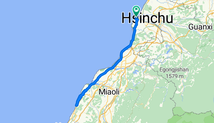
20120527_新竹郵局:挑戰西濱101
A cycling route starting in Hsinchu, Taiwan, Taiwan.
Overview
About this route
<span style="color: #000000; font-family: Helvetica, Verdana, 'LiHei Pro', 新細明體, sans-serif; font-size: 15px; letter-spacing: 1px; line-height: 22px;">新竹南寮漁港→新港二路→天府路二段→榮濱路→台 15 線西濱公路→61 線快速道路 103Km</span><br style="letter-spacing: 0em; text-shadow: none !important; color: #000000; font-family: Helvetica, Verdana, 'LiHei Pro', 新細明體, sans-serif; font-size: 15px; line-height: 22px;" /><span style="color: #000000; font-family: Helvetica, Verdana, 'LiHei Pro', 新細明體, sans-serif; font-size: 15px; letter-spacing: 1px; line-height: 22px;">→右轉後龍好望角→貝殼山→通霄秋茂園後門海岸風景區 (折返點)</span><br style="letter-spacing: 0em; text-shadow: none !important; color: #000000; font-family: Helvetica, Verdana, 'LiHei Pro', 新細明體, sans-serif; font-size: 15px; line-height: 22px;" /><span style="color: #000000; font-family: Helvetica, Verdana, 'LiHei Pro', 新細明體, sans-serif; font-size: 15px; letter-spacing: 1px; line-height: 22px;">→通霄秋茂園前門過鐵路平交道→台一線縱貫公路</span><br style="letter-spacing: 0em; text-shadow: none !important; color: #000000; font-family: Helvetica, Verdana, 'LiHei Pro', 新細明體, sans-serif; font-size: 15px; line-height: 22px;" /><span style="color: #000000; font-family: Helvetica, Verdana, 'LiHei Pro', 新細明體, sans-serif; font-size: 15px; letter-spacing: 1px; line-height: 22px;">→61 線西濱快速道路按原路線回新竹南寮漁港 (終點)</span>
- -:--
- Duration
- 93.4 km
- Distance
- 266 m
- Ascent
- 265 m
- Descent
- ---
- Avg. speed
- ---
- Max. altitude

Continue with Bikemap
Use, edit, or download this cycling route
You would like to ride 20120527_新竹郵局:挑戰西濱101 or customize it for your own trip? Here is what you can do with this Bikemap route:
Free features
- Save this route as favorite or in collections
- Copy & plan your own version of this route
- Split it into stages to create a multi-day tour
- Sync your route with Garmin or Wahoo
Premium features
Free trial for 3 days, or one-time payment. More about Bikemap Premium.
- Navigate this route on iOS & Android
- Export a GPX / KML file of this route
- Create your custom printout (try it for free)
- Download this route for offline navigation
Discover more Premium features.
Get Bikemap PremiumFrom our community
Other popular routes starting in Hsinchu
 竹苗水庫(2):R1
- Distance
- 38.8 km
- Ascent
- 589 m
- Descent
- 584 m
- Location
- Hsinchu, Taiwan, Taiwan
 環島I
環島I- Distance
- 1,115.9 km
- Ascent
- 1,758 m
- Descent
- 1,758 m
- Location
- Hsinchu, Taiwan, Taiwan
 飛鳳山 側面上 (A)
- Distance
- 34.2 km
- Ascent
- 281 m
- Descent
- 276 m
- Location
- Hsinchu, Taiwan, Taiwan
 教育大學_新城_水流東_永和山水庫_台一線
- Distance
- 51.3 km
- Ascent
- 492 m
- Descent
- 492 m
- Location
- Hsinchu, Taiwan, Taiwan
 寶山水庫+寶二水庫
- Distance
- 38.1 km
- Ascent
- 581 m
- Descent
- 576 m
- Location
- Hsinchu, Taiwan, Taiwan
 新竹17公里海岸
- Distance
- 37 km
- Ascent
- 51 m
- Descent
- 49 m
- Location
- Hsinchu, Taiwan, Taiwan
 20070430_峨嵋湖
- Distance
- 11.6 km
- Ascent
- 203 m
- Descent
- 186 m
- Location
- Hsinchu, Taiwan, Taiwan
 二寮神木 (Beipu)
- Distance
- 43.9 km
- Ascent
- 618 m
- Descent
- 617 m
- Location
- Hsinchu, Taiwan, Taiwan
Open it in the app