

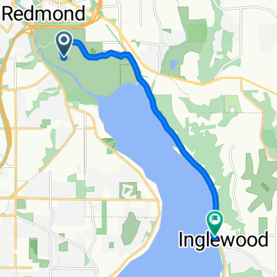
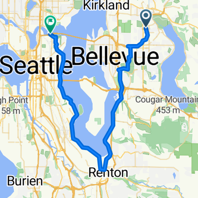
Lake Sam & Juanita hill Figure eight
A cycling route starting in Redmond, Washington, United States.
Overview
About this route
Start at Lake Sam and go over Rose Hill OR take the 520 trail into Kirkland and get on Lake WA blvd. Go North over Market and Juanita hills down into Kenmore. Get on the Burke Trail and stay on unitl after the tunnel near the golf course then go over the high bridge instead of the trail and get on the street near Bythe? park. go left & follow that unitl you come to the winery. follow the road and get back on the trail. go south and them go around the lake. I use this all the time for STP training and add a few side miles to make 60-70 miles total. Several long hills and nice scenery.
this is agreat app, but it does not lend itself to going from paved Trail to streets. there are several trail the locals know about so i would encouraged you to try those too.
- -:--
- Duration
- 94.1 km
- Distance
- 673 m
- Ascent
- 615 m
- Descent
- ---
- Avg. speed
- ---
- Max. altitude
Route quality
Waytypes & surfaces along the route
Waytypes
Busy road
61.9 km
(66 %)
Quiet road
10.7 km
(11 %)
Surfaces
Paved
70.4 km
(75 %)
Asphalt
65.1 km
(69 %)
Concrete
4.3 km
(5 %)
Continue with Bikemap
Use, edit, or download this cycling route
You would like to ride Lake Sam & Juanita hill Figure eight or customize it for your own trip? Here is what you can do with this Bikemap route:
Free features
- Save this route as favorite or in collections
- Copy & plan your own version of this route
- Split it into stages to create a multi-day tour
- Sync your route with Garmin or Wahoo
Premium features
Free trial for 3 days, or one-time payment. More about Bikemap Premium.
- Navigate this route on iOS & Android
- Export a GPX / KML file of this route
- Create your custom printout (try it for free)
- Download this route for offline navigation
Discover more Premium features.
Get Bikemap PremiumFrom our community
Other popular routes starting in Redmond
 Lake Washington Loop
- Distance
- 101 km
- Ascent
- 569 m
- Descent
- 589 m
- Location
- Redmond, Washington, United States
 East Lake Sammamish Parkway Northeast 6411, Redmond to East Lake Sammamish Parkway Northeast 6411, Redmond
- Distance
- 40 km
- Ascent
- 193 m
- Descent
- 193 m
- Location
- Redmond, Washington, United States
 sammamish loop
- Distance
- 35.2 km
- Ascent
- 195 m
- Descent
- 197 m
- Location
- Redmond, Washington, United States
 Easy ride in Sammamish
- Distance
- 7.3 km
- Ascent
- 0 m
- Descent
- 4 m
- Location
- Redmond, Washington, United States
 Redmond to Rail underlake
- Distance
- 48.2 km
- Ascent
- 188 m
- Descent
- 279 m
- Location
- Redmond, Washington, United States
 Marymoor to Snoqualmie Falls Loop
- Distance
- 65.5 km
- Ascent
- 508 m
- Descent
- 508 m
- Location
- Redmond, Washington, United States
 Overlake to Bellevue Downtown Park
- Distance
- 9.9 km
- Ascent
- 141 m
- Descent
- 198 m
- Location
- Redmond, Washington, United States
 17525 NE 65th St, Redmond to 17525 NE 65th St, Redmond
- Distance
- 14.5 km
- Ascent
- 12 m
- Descent
- 13 m
- Location
- Redmond, Washington, United States
Open it in the app