

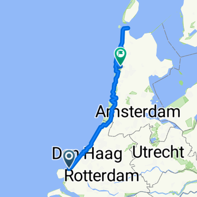
NL - Day 1 (24/10/24)
A cycling route starting in Hoek van Holland, South Holland, The Netherlands.
Overview
About this route
- 3 h 33 min
- Duration
- 57.7 km
- Distance
- 161 m
- Ascent
- 166 m
- Descent
- 16.2 km/h
- Avg. speed
- 28 m
- Max. altitude
Route quality
Waytypes & surfaces along the route
Waytypes
Cycleway
44.5 km
(77 %)
Quiet road
10.6 km
(18 %)
Surfaces
Paved
49.1 km
(85 %)
Asphalt
44.3 km
(77 %)
Paving stones
4.1 km
(7 %)
Continue with Bikemap
Use, edit, or download this cycling route
You would like to ride NL - Day 1 (24/10/24) or customize it for your own trip? Here is what you can do with this Bikemap route:
Free features
- Save this route as favorite or in collections
- Copy & plan your own version of this route
- Sync your route with Garmin or Wahoo
Premium features
Free trial for 3 days, or one-time payment. More about Bikemap Premium.
- Navigate this route on iOS & Android
- Export a GPX / KML file of this route
- Create your custom printout (try it for free)
- Download this route for offline navigation
Discover more Premium features.
Get Bikemap PremiumFrom our community
Other popular routes starting in Hoek van Holland
 Periple 11 / 32
- Distance
- 161.8 km
- Ascent
- 98 m
- Descent
- 60 m
- Location
- Hoek van Holland, South Holland, The Netherlands
 Hoek van Holland-Nieweschans
- Distance
- 553.3 km
- Ascent
- 55 m
- Descent
- 65 m
- Location
- Hoek van Holland, South Holland, The Netherlands
 Easter 2025
- Distance
- 200.9 km
- Ascent
- 636 m
- Descent
- 624 m
- Location
- Hoek van Holland, South Holland, The Netherlands
 Easter Cycling
- Distance
- 201.4 km
- Ascent
- 639 m
- Descent
- 627 m
- Location
- Hoek van Holland, South Holland, The Netherlands
 CYCLING THE RHINE: Route Approach D
- Distance
- 115.8 km
- Ascent
- 12 m
- Descent
- 13 m
- Location
- Hoek van Holland, South Holland, The Netherlands
 Europort - Alkmaar -1
- Distance
- 127.6 km
- Ascent
- 301 m
- Descent
- 304 m
- Location
- Hoek van Holland, South Holland, The Netherlands
 Hook to Rotterdam
- Distance
- 30.6 km
- Ascent
- 39 m
- Descent
- 41 m
- Location
- Hoek van Holland, South Holland, The Netherlands
 Hook of Holland, Hoek van Holland to Hook of Holland, Hoek van Holland
- Distance
- 46.7 km
- Ascent
- 252 m
- Descent
- 342 m
- Location
- Hoek van Holland, South Holland, The Netherlands
Open it in the app