planegg-ammerseeeee
A cycling route starting in Planegg, Bavaria, Germany.
Overview
About this route
It was nice. Small roads
- -:--
- Duration
- 72.1 km
- Distance
- 328 m
- Ascent
- 328 m
- Descent
- ---
- Avg. speed
- ---
- Max. altitude
Route quality
Waytypes & surfaces along the route
Waytypes
Quiet road
23.8 km
(33 %)
Road
9.4 km
(13 %)
Surfaces
Paved
62 km
(86 %)
Unpaved
4.3 km
(6 %)
Asphalt
61.3 km
(85 %)
Gravel
3.6 km
(5 %)
Continue with Bikemap
Use, edit, or download this cycling route
You would like to ride planegg-ammerseeeee or customize it for your own trip? Here is what you can do with this Bikemap route:
Free features
- Save this route as favorite or in collections
- Copy & plan your own version of this route
- Sync your route with Garmin or Wahoo
Premium features
Free trial for 3 days, or one-time payment. More about Bikemap Premium.
- Navigate this route on iOS & Android
- Export a GPX / KML file of this route
- Create your custom printout (try it for free)
- Download this route for offline navigation
Discover more Premium features.
Get Bikemap PremiumFrom our community
Other popular routes starting in Planegg
- Krailling Isar
- Distance
- 41 km
- Ascent
- 310 m
- Descent
- 310 m
- Location
- Planegg, Bavaria, Germany
- S6 Planegg Rund um den Starnberger See
- Distance
- 79.4 km
- Ascent
- 241 m
- Descent
- 239 m
- Location
- Planegg, Bavaria, Germany
- Krailling-Radfeld2
- Distance
- 104.5 km
- Ascent
- 1,007 m
- Descent
- 1,048 m
- Location
- Planegg, Bavaria, Germany
- Krailling - Germeringer See by Kovi
- Distance
- 8.8 km
- Ascent
- 9 m
- Descent
- 21 m
- Location
- Planegg, Bavaria, Germany
- Krailling - Buchenhain - Isar - Gauting
- Distance
- 41.6 km
- Ascent
- 305 m
- Descent
- 304 m
- Location
- Planegg, Bavaria, Germany
- Planegg FT
- Distance
- 15.3 km
- Ascent
- 1,576 m
- Descent
- 1,581 m
- Location
- Planegg, Bavaria, Germany
- planegg-ammerseeeee
- Distance
- 72.1 km
- Ascent
- 328 m
- Descent
- 328 m
- Location
- Planegg, Bavaria, Germany
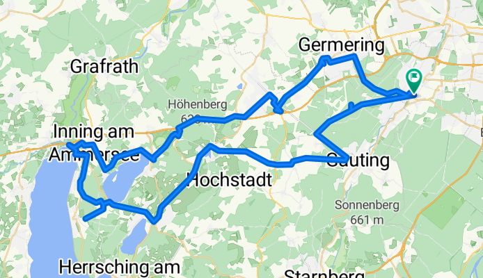
- Würmtal-Krailling-Starnberg
- Distance
- 30.4 km
- Ascent
- 214 m
- Descent
- 213 m
- Location
- Planegg, Bavaria, Germany
Open it in the app