

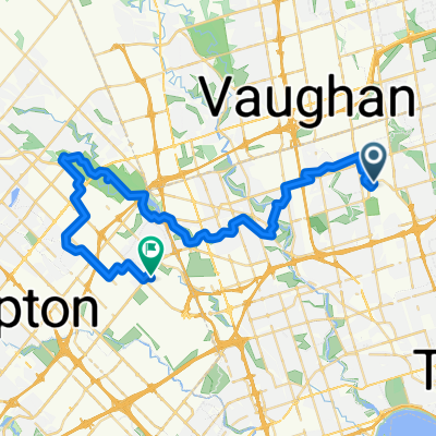
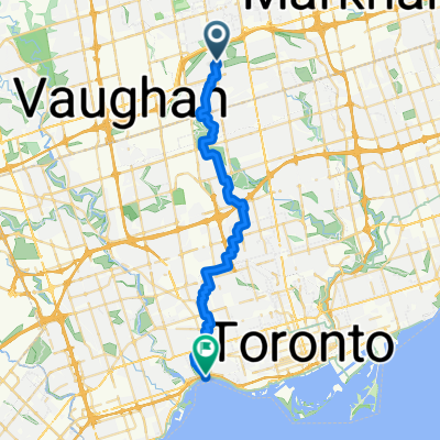
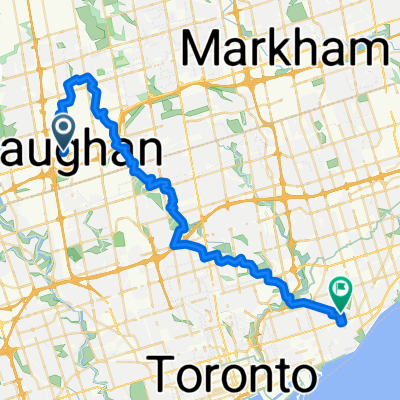
Vaughan to Toronto Island
A cycling route starting in Concord, Ontario, Canada.
Overview
About this route
54 KM downhill ride from Vaughan to Toronto Island
- 3 h 24 min
- Duration
- 54.2 km
- Distance
- 242 m
- Ascent
- 355 m
- Descent
- 15.9 km/h
- Avg. speed
- 207 m
- Max. altitude

Route quality
Waytypes & surfaces along the route
Waytypes
Quiet road
15.7 km
(29 %)
Cycleway
14.1 km
(26 %)
Surfaces
Paved
42.2 km
(78 %)
Unpaved
1.1 km
(2 %)
Asphalt
40.1 km
(74 %)
Concrete
1.6 km
(3 %)
Continue with Bikemap
Use, edit, or download this cycling route
You would like to ride Vaughan to Toronto Island or customize it for your own trip? Here is what you can do with this Bikemap route:
Free features
- Save this route as favorite or in collections
- Copy & plan your own version of this route
- Sync your route with Garmin or Wahoo
Premium features
Free trial for 3 days, or one-time payment. More about Bikemap Premium.
- Navigate this route on iOS & Android
- Export a GPX / KML file of this route
- Create your custom printout (try it for free)
- Download this route for offline navigation
Discover more Premium features.
Get Bikemap PremiumFrom our community
Other popular routes starting in Concord
 Highcliffe Drive to Roncesvalles Avenue
- Distance
- 85.2 km
- Ascent
- 430 m
- Descent
- 503 m
- Location
- Concord, Ontario, Canada
 Vaughan Subway Down Humber Rver to Lakeshore, End Unon Station
- Distance
- 36.6 km
- Ascent
- 267 m
- Descent
- 267 m
- Location
- Concord, Ontario, Canada
 Downsview Park to Malton Via West Humber and Claireville Ranch
- Distance
- 43.9 km
- Ascent
- 216 m
- Descent
- 239 m
- Location
- Concord, Ontario, Canada
 Kleinburg
- Distance
- 40.9 km
- Ascent
- 263 m
- Descent
- 263 m
- Location
- Concord, Ontario, Canada
 Heart Lake
- Distance
- 53.2 km
- Ascent
- ---
- Descent
- ---
- Location
- Concord, Ontario, Canada
 Route Thornhill to Sunnyside Beach
- Distance
- 30.1 km
- Ascent
- 88 m
- Descent
- 219 m
- Location
- Concord, Ontario, Canada
 Jack and Randi Sunday Ride
- Distance
- 34.9 km
- Ascent
- 200 m
- Descent
- 202 m
- Location
- Concord, Ontario, Canada
 From Vaughan to Victoria Park Via BS Greenway, GRoss Lord, Earl Bales, Glendon Forest, Sunnybrook, Taylor Creek
- Distance
- 46.5 km
- Ascent
- 283 m
- Descent
- 357 m
- Location
- Concord, Ontario, Canada
Open it in the app