

2012_05_01 Schlangenweg
A cycling route starting in Knetzgau, Bavaria, Germany.
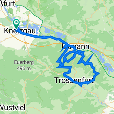
Overview
About this route
Hiking - Biketour from Zell steeply up the very beautiful, partly exposed footpath/trails towards Neuhaus. After 8.5 km descent into Böhlgrund and back to Zell. There, a stop in various wine taverns at winemakers.
- -:--
- Duration
- 12.3 km
- Distance
- 330 m
- Ascent
- 331 m
- Descent
- ---
- Avg. speed
- ---
- Max. altitude

Continue with Bikemap
Use, edit, or download this cycling route
You would like to ride 2012_05_01 Schlangenweg or customize it for your own trip? Here is what you can do with this Bikemap route:
Free features
- Save this route as favorite or in collections
- Copy & plan your own version of this route
- Sync your route with Garmin or Wahoo
Premium features
Free trial for 3 days, or one-time payment. More about Bikemap Premium.
- Navigate this route on iOS & Android
- Export a GPX / KML file of this route
- Create your custom printout (try it for free)
- Download this route for offline navigation
Discover more Premium features.
Get Bikemap PremiumFrom our community
Other popular routes starting in Knetzgau
 Schweinfurt
- Distance
- 68.4 km
- Ascent
- 862 m
- Descent
- 837 m
- Location
- Knetzgau, Bavaria, Germany
 Freizeit-/Panoramatour
- Distance
- 41 km
- Ascent
- 309 m
- Descent
- 248 m
- Location
- Knetzgau, Bavaria, Germany
 Eschenau mit Führung Hermann de Vries nach Eltmann
- Distance
- 29.3 km
- Ascent
- 540 m
- Descent
- 607 m
- Location
- Knetzgau, Bavaria, Germany
 Nördlicher Steigerwald
- Distance
- 51.1 km
- Ascent
- 907 m
- Descent
- 908 m
- Location
- Knetzgau, Bavaria, Germany
 Tretzendorf
- Distance
- 52.3 km
- Ascent
- 724 m
- Descent
- 724 m
- Location
- Knetzgau, Bavaria, Germany
 1 Volkach-Prichsenstadt
- Distance
- 75.3 km
- Ascent
- 373 m
- Descent
- 373 m
- Location
- Knetzgau, Bavaria, Germany
 Zell Sportplatz zum grossen knetzberg
- Distance
- 11.1 km
- Ascent
- 310 m
- Descent
- 304 m
- Location
- Knetzgau, Bavaria, Germany
 Königsberg _2
- Distance
- 70 km
- Ascent
- 971 m
- Descent
- 982 m
- Location
- Knetzgau, Bavaria, Germany
Open it in the app