
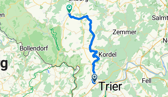
Vom Trierweiler Rennen nach Messerich ohne B51
A cycling route starting in Aach, Rhineland-Palatinate, Germany.
Overview
About this route
Auf dem "Sattel" zwischen Kyll- und Sauertal ohne Nutzung der stark befahrenen B51
- -:--
- Duration
- 32.2 km
- Distance
- 504 m
- Ascent
- 538 m
- Descent
- ---
- Avg. speed
- 389 m
- Avg. speed

Route quality
Waytypes & surfaces along the route
Waytypes
Road
17.3 km
(54 %)
Track
5.8 km
(18 %)
Surfaces
Paved
23 km
(71 %)
Unpaved
0.9 km
(3 %)
Asphalt
20.6 km
(64 %)
Paved (undefined)
2.4 km
(7 %)
Continue with Bikemap
Use, edit, or download this cycling route
You would like to ride Vom Trierweiler Rennen nach Messerich ohne B51 or customize it for your own trip? Here is what you can do with this Bikemap route:
Free features
- Save this route as favorite or in collections
- Copy & plan your own version of this route
- Sync your route with Garmin or Wahoo
Premium features
Free trial for 3 days, or one-time payment. More about Bikemap Premium.
- Navigate this route on iOS & Android
- Export a GPX / KML file of this route
- Create your custom printout (try it for free)
- Download this route for offline navigation
Discover more Premium features.
Get Bikemap PremiumFrom our community
Other popular routes starting in Aach
 Vom Trierweiler Rennen nach Messerich ohne B51
- Distance
- 32.2 km
- Ascent
- 504 m
- Descent
- 538 m
- Location
- Aach, Rhineland-Palatinate, Germany
 Tour 15f Sizernich 5 Wie
- Distance
- 4.5 km
- Ascent
- 72 m
- Descent
- 113 m
- Location
- Aach, Rhineland-Palatinate, Germany
 Mountainbike Weisshauswald
- Distance
- 21.1 km
- Ascent
- 576 m
- Descent
- 571 m
- Location
- Aach, Rhineland-Palatinate, Germany
 Moselradtour Trier - Koblenz Teil1
- Distance
- 109 km
- Ascent
- 147 m
- Descent
- 394 m
- Location
- Aach, Rhineland-Palatinate, Germany
 Mosel + Hunsrück + Eifel + Kyll
- Distance
- 101 km
- Ascent
- 1,150 m
- Descent
- 1,143 m
- Location
- Aach, Rhineland-Palatinate, Germany
 Feller Berg - Piesport - Hetzerrath
- Distance
- 88.8 km
- Ascent
- 885 m
- Descent
- 881 m
- Location
- Aach, Rhineland-Palatinate, Germany
 Hausrunde
- Distance
- 101.7 km
- Ascent
- 736 m
- Descent
- 736 m
- Location
- Aach, Rhineland-Palatinate, Germany
 Mosel Eifel Runde
- Distance
- 98.3 km
- Ascent
- 1,095 m
- Descent
- 1,095 m
- Location
- Aach, Rhineland-Palatinate, Germany
Open it in the app