
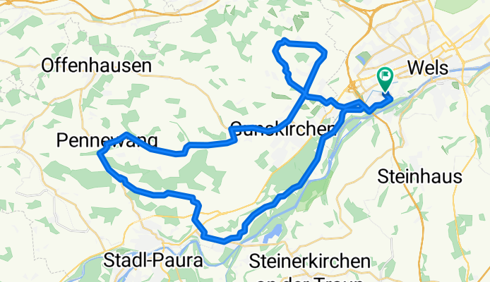
Wels - Riethal - Pennewang - Wels
A cycling route starting in Thalheim bei Wels, Upper Austria, Austria.
Overview
About this route
A beautiful route starting from Wels/West. Passing through the 'Tuscany of Wels', touched upon in a 'ceremonial lap', and past the well-known farms in the west of Wels, the path leads always on paved roads to Gunskirchen. From there, it continues westward to Pennewang, where the journey back home begins. Just after Pennewang is the only real climb on this route, which then continues via Edt/Lambach and then the bike path back to Wels.
Scenically wonderful, on rather quiet roads and past interesting villages and farms. Truly a very nice ride.
- -:--
- Duration
- 41.4 km
- Distance
- 182 m
- Ascent
- 184 m
- Descent
- ---
- Avg. speed
- ---
- Max. altitude
Route quality
Waytypes & surfaces along the route
Waytypes
Quiet road
21.1 km
(51 %)
Road
10.3 km
(25 %)
Surfaces
Paved
6.2 km
(15 %)
Unpaved
1.2 km
(3 %)
Asphalt
6.2 km
(15 %)
Unpaved (undefined)
1.2 km
(3 %)
Undefined
33.9 km
(82 %)
Continue with Bikemap
Use, edit, or download this cycling route
You would like to ride Wels - Riethal - Pennewang - Wels or customize it for your own trip? Here is what you can do with this Bikemap route:
Free features
- Save this route as favorite or in collections
- Copy & plan your own version of this route
- Sync your route with Garmin or Wahoo
Premium features
Free trial for 3 days, or one-time payment. More about Bikemap Premium.
- Navigate this route on iOS & Android
- Export a GPX / KML file of this route
- Create your custom printout (try it for free)
- Download this route for offline navigation
Discover more Premium features.
Get Bikemap PremiumFrom our community
Other popular routes starting in Thalheim bei Wels
 WÖS CALLING
- Distance
- 239.3 km
- Ascent
- 124 m
- Descent
- 254 m
- Location
- Thalheim bei Wels, Upper Austria, Austria
 Wels-Lambach-Wels
- Distance
- 41.1 km
- Ascent
- 493 m
- Descent
- 494 m
- Location
- Thalheim bei Wels, Upper Austria, Austria
 Wels nach Leonding
- Distance
- 31.7 km
- Ascent
- 71 m
- Descent
- 113 m
- Location
- Thalheim bei Wels, Upper Austria, Austria
 WelsWest-Scharten(Roithen)-WelsWest
- Distance
- 45.6 km
- Ascent
- 568 m
- Descent
- 564 m
- Location
- Thalheim bei Wels, Upper Austria, Austria
 Wels nach Linz Magdalena2
- Distance
- 40.3 km
- Ascent
- 95 m
- Descent
- 145 m
- Location
- Thalheim bei Wels, Upper Austria, Austria
 Von Wels bis Schlüßlberg
- Distance
- 17.6 km
- Ascent
- 357 m
- Descent
- 345 m
- Location
- Thalheim bei Wels, Upper Austria, Austria
 Lindenstraße 24, Wels nach Steinbergstraße 5, Marchtrenk
- Distance
- 12.6 km
- Ascent
- 3 m
- Descent
- 67 m
- Location
- Thalheim bei Wels, Upper Austria, Austria
 Wels Messe - Sipbachzell - Golfplatz Kematen adK Ritzlhof - Haid - Marchtrenk - Wels
- Distance
- 62.9 km
- Ascent
- 523 m
- Descent
- 521 m
- Location
- Thalheim bei Wels, Upper Austria, Austria
Open it in the app