

Norwottuck Branch Rail Trail, Belchertown to Norwottuck Branch Rail Trail, Belchertown
A cycling route starting in South Amherst, Massachusetts, United States of America.
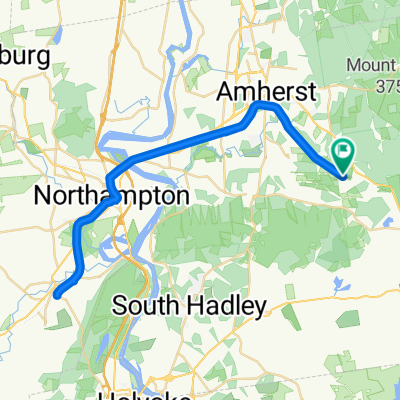
Overview
About this route
- 5 h 15 min
- Duration
- 53.1 km
- Distance
- 409 m
- Ascent
- 402 m
- Descent
- 10.1 km/h
- Avg. speed
- 90 m
- Avg. speed
Route quality
Waytypes & surfaces along the route
Waytypes
Cycleway
50 km
(94 %)
Quiet road
1.2 km
(2 %)
Surfaces
Paved
51.1 km
(96 %)
Asphalt
36.6 km
(69 %)
Paved (undefined)
13.2 km
(25 %)
Continue with Bikemap
Use, edit, or download this cycling route
You would like to ride Norwottuck Branch Rail Trail, Belchertown to Norwottuck Branch Rail Trail, Belchertown or customize it for your own trip? Here is what you can do with this Bikemap route:
Free features
- Save this route as favorite or in collections
- Copy & plan your own version of this route
- Sync your route with Garmin or Wahoo
Premium features
Free trial for 3 days, or one-time payment. More about Bikemap Premium.
- Navigate this route on iOS & Android
- Export a GPX / KML file of this route
- Create your custom printout (try it for free)
- Download this route for offline navigation
Discover more Premium features.
Get Bikemap PremiumFrom our community
Other popular routes starting in South Amherst
 Norwottuck Branch Rail Trail, Belchertown to Norwottuck Branch Rail Trail, Belchertown
- Distance
- 53.1 km
- Ascent
- 409 m
- Descent
- 402 m
- Location
- South Amherst, Massachusetts, United States of America
 Johannes Big Amherst Loop #1
- Distance
- 26.9 km
- Ascent
- 240 m
- Descent
- 241 m
- Location
- South Amherst, Massachusetts, United States of America
 Big momma day
- Distance
- 88.4 km
- Ascent
- 567 m
- Descent
- 564 m
- Location
- South Amherst, Massachusetts, United States of America
 Round Quabbin loop 61
- Distance
- 98.3 km
- Ascent
- 1,500 m
- Descent
- 1,501 m
- Location
- South Amherst, Massachusetts, United States of America
 Norwottuck to Look Park
- Distance
- 47.2 km
- Ascent
- 188 m
- Descent
- 188 m
- Location
- South Amherst, Massachusetts, United States of America
 Medium Amherst-Bay Road Loop
- Distance
- 19.9 km
- Ascent
- 208 m
- Descent
- 207 m
- Location
- South Amherst, Massachusetts, United States of America
 Short ride to Amherst
- Distance
- 16.9 km
- Ascent
- 161 m
- Descent
- 162 m
- Location
- South Amherst, Massachusetts, United States of America
 Long ride to Metacomet and Amherst
- Distance
- 27.7 km
- Ascent
- 217 m
- Descent
- 213 m
- Location
- South Amherst, Massachusetts, United States of America
Open it in the app