

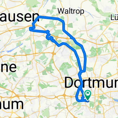
Wellinghofer RTF 41km-Strecke
A cycling route starting in Dortmund, North Rhine-Westphalia, Germany.
Overview
About this route
Wellinghofer RTF 41 km route status 2014
- -:--
- Duration
- 39.2 km
- Distance
- 309 m
- Ascent
- 309 m
- Descent
- ---
- Avg. speed
- ---
- Max. altitude
Route quality
Waytypes & surfaces along the route
Waytypes
Quiet road
19.6 km
(50 %)
Road
4.3 km
(11 %)
Surfaces
Paved
32.1 km
(82 %)
Asphalt
32.1 km
(82 %)
Undefined
7.1 km
(18 %)
Route highlights
Points of interest along the route
Point of interest after 25.6 km
Kontrolle I Wellenbad
Point of interest after 27.4 km
Streckenteilung Rechts 74km, 110km,151km
Continue with Bikemap
Use, edit, or download this cycling route
You would like to ride Wellinghofer RTF 41km-Strecke or customize it for your own trip? Here is what you can do with this Bikemap route:
Free features
- Save this route as favorite or in collections
- Copy & plan your own version of this route
- Sync your route with Garmin or Wahoo
Premium features
Free trial for 3 days, or one-time payment. More about Bikemap Premium.
- Navigate this route on iOS & Android
- Export a GPX / KML file of this route
- Create your custom printout (try it for free)
- Download this route for offline navigation
Discover more Premium features.
Get Bikemap PremiumFrom our community
Other popular routes starting in Dortmund
 Rundtour Dortmund
- Distance
- 30.2 km
- Ascent
- 123 m
- Descent
- 125 m
- Location
- Dortmund, North Rhine-Westphalia, Germany
 Emscherradweg bis Rhein Herne Kanal
- Distance
- 49.6 km
- Ascent
- 114 m
- Descent
- 113 m
- Location
- Dortmund, North Rhine-Westphalia, Germany
 Sonntagstour
- Distance
- 80.2 km
- Ascent
- 248 m
- Descent
- 248 m
- Location
- Dortmund, North Rhine-Westphalia, Germany
 Winterrunde
- Distance
- 31.4 km
- Ascent
- 144 m
- Descent
- 141 m
- Location
- Dortmund, North Rhine-Westphalia, Germany
 DO - Schwerte - Iserlohn - Hohensyburg - DO
- Distance
- 60.9 km
- Ascent
- 552 m
- Descent
- 552 m
- Location
- Dortmund, North Rhine-Westphalia, Germany
 Kanal runter, Emscher rauf
- Distance
- 36.1 km
- Ascent
- 45 m
- Descent
- 48 m
- Location
- Dortmund, North Rhine-Westphalia, Germany
 November Rain - Bike
- Distance
- 18.6 km
- Ascent
- 457 m
- Descent
- 457 m
- Location
- Dortmund, North Rhine-Westphalia, Germany
 Runde: DO-Ems-Kanal hoch - Emscher-Weg runter
- Distance
- 21.8 km
- Ascent
- 76 m
- Descent
- 78 m
- Location
- Dortmund, North Rhine-Westphalia, Germany
Open it in the app