

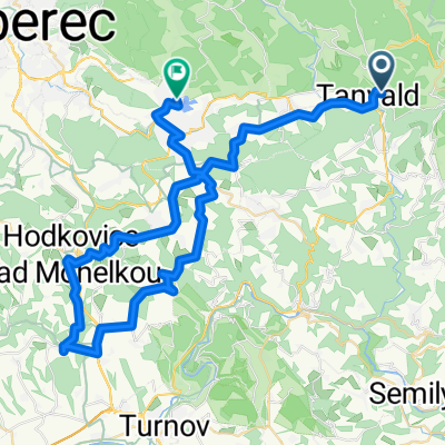
Jizerské hory
A cycling route starting in Tanvald, Liberecký kraj, Czechia.
Overview
About this route
- 7 h 6 min
- Duration
- 69 km
- Distance
- 1,252 m
- Ascent
- 1,324 m
- Descent
- 9.7 km/h
- Avg. speed
- 1,002 m
- Max. altitude

Route photos

Route quality
Waytypes & surfaces along the route
Waytypes
Track
36.6 km
(53 %)
Road
15.9 km
(23 %)
Surfaces
Paved
62.8 km
(91 %)
Unpaved
0.7 km
(1 %)
Asphalt
55.2 km
(80 %)
Concrete
6.9 km
(10 %)
Continue with Bikemap
Use, edit, or download this cycling route
You would like to ride Jizerské hory or customize it for your own trip? Here is what you can do with this Bikemap route:
Free features
- Save this route as favorite or in collections
- Copy & plan your own version of this route
- Sync your route with Garmin or Wahoo
Premium features
Free trial for 3 days, or one-time payment. More about Bikemap Premium.
- Navigate this route on iOS & Android
- Export a GPX / KML file of this route
- Create your custom printout (try it for free)
- Download this route for offline navigation
Discover more Premium features.
Get Bikemap PremiumFrom our community
Other popular routes starting in Tanvald
 šumburk-semily-kozákov-ž.brod-bozkov-žumburk
- Distance
- 81.4 km
- Ascent
- 1,664 m
- Descent
- 1,529 m
- Location
- Tanvald, Liberecký kraj, Czechia
 Zlaťák clasic
- Distance
- 83 km
- Ascent
- 1,877 m
- Descent
- 1,877 m
- Location
- Tanvald, Liberecký kraj, Czechia
 tanvald-přichovice-jablonec n/J-Vysoké-Kořenov-Tanvald
- Distance
- 55.8 km
- Ascent
- 851 m
- Descent
- 867 m
- Location
- Tanvald, Liberecký kraj, Czechia
 Tanvald - Železný Brod - Malá Skála - Kopanina - Císařův kámen - Liberec
- Distance
- 68.1 km
- Ascent
- 1,116 m
- Descent
- 1,212 m
- Location
- Tanvald, Liberecký kraj, Czechia
 Zlaté návrší / Labská bouda (plán na 2.6.2013)
- Distance
- 137.2 km
- Ascent
- 2,395 m
- Descent
- 2,595 m
- Location
- Tanvald, Liberecký kraj, Czechia
 Tanvald - Jelena Gora
- Distance
- 48 km
- Ascent
- 628 m
- Descent
- 740 m
- Location
- Tanvald, Liberecký kraj, Czechia
 Sychrov
- Distance
- 54.9 km
- Ascent
- 755 m
- Descent
- 748 m
- Location
- Tanvald, Liberecký kraj, Czechia
 Po Jizerských loučkách
- Distance
- 58.6 km
- Ascent
- 901 m
- Descent
- 909 m
- Location
- Tanvald, Liberecký kraj, Czechia
Open it in the app