
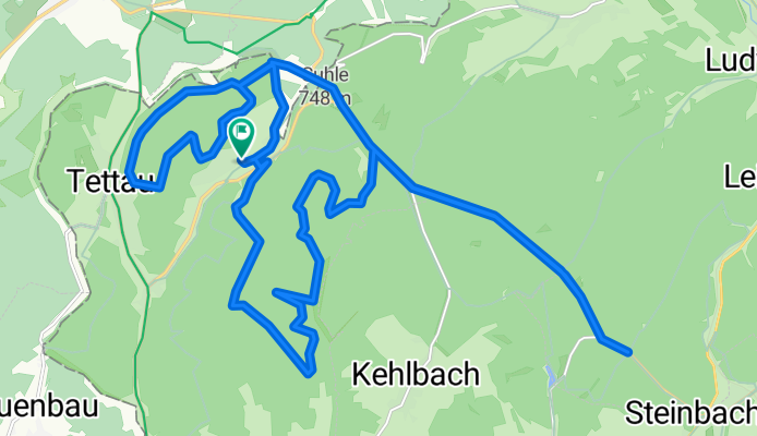
In den Wäldern bei Kleintettau
A cycling route starting in Tettau, Bavaria, Germany.
Overview
About this route
20 km of forest paths, 10 km of paved bike paths.
Challenging due to the gravel paths.
Clear air, pleasant riding sensation.
- -:--
- Duration
- 29.3 km
- Distance
- 392 m
- Ascent
- 392 m
- Descent
- ---
- Avg. speed
- ---
- Max. altitude

Route quality
Waytypes & surfaces along the route
Waytypes
Track
18.2 km
(62 %)
Path
3.8 km
(13 %)
Surfaces
Paved
11.1 km
(38 %)
Unpaved
14.4 km
(49 %)
Gravel
14.1 km
(48 %)
Asphalt
11.1 km
(38 %)
Continue with Bikemap
Use, edit, or download this cycling route
You would like to ride In den Wäldern bei Kleintettau or customize it for your own trip? Here is what you can do with this Bikemap route:
Free features
- Save this route as favorite or in collections
- Copy & plan your own version of this route
- Sync your route with Garmin or Wahoo
Premium features
Free trial for 3 days, or one-time payment. More about Bikemap Premium.
- Navigate this route on iOS & Android
- Export a GPX / KML file of this route
- Create your custom printout (try it for free)
- Download this route for offline navigation
Discover more Premium features.
Get Bikemap PremiumFrom our community
Other popular routes starting in Tettau
 2022-08-11 Kleintettau nach Untersiemau
- Distance
- 55.9 km
- Ascent
- 358 m
- Descent
- 694 m
- Location
- Tettau, Bavaria, Germany
 zum Bärenbach bei Langenau
- Distance
- 20.7 km
- Ascent
- 317 m
- Descent
- 317 m
- Location
- Tettau, Bavaria, Germany
 Rennsteig, -Loquitztal - Taugwitztal
- Distance
- 25.6 km
- Ascent
- 435 m
- Descent
- 413 m
- Location
- Tettau, Bavaria, Germany
 zwischen Thüringer Wald und Schiefergebirge
- Distance
- 68.1 km
- Ascent
- 844 m
- Descent
- 1,023 m
- Location
- Tettau, Bavaria, Germany
 20-8-14 Vom Rennsteig nach Kronach
- Distance
- 31.7 km
- Ascent
- 19 m
- Descent
- 369 m
- Location
- Tettau, Bavaria, Germany
 Rund um Hasenthal
- Distance
- 21.5 km
- Ascent
- 546 m
- Descent
- 523 m
- Location
- Tettau, Bavaria, Germany
 Der Rennsteig - bayrischer Teil Schildwiese-Ziegelhütte
- Distance
- 24.7 km
- Ascent
- 346 m
- Descent
- 346 m
- Location
- Tettau, Bavaria, Germany
 Unterhalb von Lichtenhain :)
- Distance
- 24 km
- Ascent
- 625 m
- Descent
- 625 m
- Location
- Tettau, Bavaria, Germany
Open it in the app