
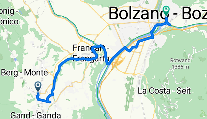
Krafußweg 14, Eppan an der Weinstraße nach Piazza della Parrocchia 13, Bozen
A cycling route starting in San Michele, Trentino-Alto Adige, Italy.
Overview
About this route
- 1 h 8 min
- Duration
- 15.1 km
- Distance
- 342 m
- Ascent
- 501 m
- Descent
- 13.3 km/h
- Avg. speed
- 430 m
- Avg. speed
Route quality
Waytypes & surfaces along the route
Waytypes
Cycleway
8.3 km
(55 %)
Busy road
2.4 km
(16 %)
Surfaces
Paved
12.5 km
(83 %)
Asphalt
12.2 km
(81 %)
Paving stones
0.1 km
(<1 %)
Continue with Bikemap
Use, edit, or download this cycling route
You would like to ride Krafußweg 14, Eppan an der Weinstraße nach Piazza della Parrocchia 13, Bozen or customize it for your own trip? Here is what you can do with this Bikemap route:
Free features
- Save this route as favorite or in collections
- Copy & plan your own version of this route
- Sync your route with Garmin or Wahoo
Premium features
Free trial for 3 days, or one-time payment. More about Bikemap Premium.
- Navigate this route on iOS & Android
- Export a GPX / KML file of this route
- Create your custom printout (try it for free)
- Download this route for offline navigation
Discover more Premium features.
Get Bikemap PremiumFrom our community
Other popular routes starting in San Michele
 St. Michel - Trient_14_11_19
- Distance
- 58.9 km
- Ascent
- 57 m
- Descent
- 278 m
- Location
- San Michele, Trentino-Alto Adige, Italy
 95km roundtrip Mendel pass Calteren.
- Distance
- 95.8 km
- Ascent
- 1,250 m
- Descent
- 1,250 m
- Location
- San Michele, Trentino-Alto Adige, Italy
 Tour Strada del Vino e Bolzano
- Distance
- 50.1 km
- Ascent
- 363 m
- Descent
- 363 m
- Location
- San Michele, Trentino-Alto Adige, Italy
 Perdoing/Gaid
- Distance
- 27.8 km
- Ascent
- 797 m
- Descent
- 797 m
- Location
- San Michele, Trentino-Alto Adige, Italy
 MTB-Tour durch den Montiggler Wald
- Distance
- 19.3 km
- Ascent
- 0 m
- Descent
- 0 m
- Location
- San Michele, Trentino-Alto Adige, Italy
 Mendel-, Gampenpass, Montiggler See
- Distance
- 80.7 km
- Ascent
- 2,467 m
- Descent
- 2,417 m
- Location
- San Michele, Trentino-Alto Adige, Italy
 Dorf tirol
- Distance
- 36.4 km
- Ascent
- 170 m
- Descent
- 356 m
- Location
- San Michele, Trentino-Alto Adige, Italy
 IT San Michele - Runde nach Meran und über Narano
- Distance
- 63.5 km
- Ascent
- 976 m
- Descent
- 976 m
- Location
- San Michele, Trentino-Alto Adige, Italy
Open it in the app