

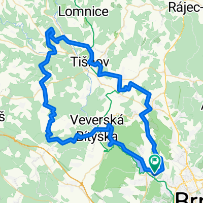
Brno - Ochoz u Brna - Křtiny - Vranov - Brno
A cycling route starting in Mokrá Hora, South Moravian, Czechia.
Overview
About this route
středně náročná kopcovitá trasa (součet nastoupaných výškových metrů dle tachometru - cca 950 m)
na trase několik stoupání odpovídajících 4. kategorii dle TDF
v úseku od Maloměřického mostu na Velkou Klajdovku kopec se sklonem až 13%
absolováno v dubnu 2012 za 30-ti stupňových veder
- -:--
- Duration
- 64.8 km
- Distance
- 797 m
- Ascent
- 797 m
- Descent
- ---
- Avg. speed
- ---
- Avg. speed
Route quality
Waytypes & surfaces along the route
Waytypes
Road
26 km
(40 %)
Quiet road
14.7 km
(23 %)
Surfaces
Paved
60.5 km
(93 %)
Unpaved
0.9 km
(1 %)
Asphalt
59.1 km
(91 %)
Paving stones
0.8 km
(1 %)
Route highlights
Points of interest along the route
Point of interest after 10.4 km
horská prémie 4.kategorie
Point of interest after 16.7 km
horská prémie 4.kategorie
Point of interest after 21.8 km
horská prémie 4.kategorie
Point of interest after 52.9 km
horská prémie 4.kategorie
Continue with Bikemap
Use, edit, or download this cycling route
You would like to ride Brno - Ochoz u Brna - Křtiny - Vranov - Brno or customize it for your own trip? Here is what you can do with this Bikemap route:
Free features
- Save this route as favorite or in collections
- Copy & plan your own version of this route
- Sync your route with Garmin or Wahoo
Premium features
Free trial for 3 days, or one-time payment. More about Bikemap Premium.
- Navigate this route on iOS & Android
- Export a GPX / KML file of this route
- Create your custom printout (try it for free)
- Download this route for offline navigation
Discover more Premium features.
Get Bikemap PremiumFrom our community
Other popular routes starting in Mokrá Hora
 Prague - Brno, Euro Velo No 7, 13, 9 and 4! Etapp 5
- Distance
- 109.8 km
- Ascent
- 2,469 m
- Descent
- 2,159 m
- Location
- Mokrá Hora, South Moravian, Czechia
 Malý okruh k přehradě
- Distance
- 14.4 km
- Ascent
- 218 m
- Descent
- 215 m
- Location
- Mokrá Hora, South Moravian, Czechia
 Brno_Babylon_77_1630
- Distance
- 76.9 km
- Ascent
- 1,744 m
- Descent
- 1,744 m
- Location
- Mokrá Hora, South Moravian, Czechia
 Na nedělní odpoledne
- Distance
- 37 km
- Ascent
- 599 m
- Descent
- 600 m
- Location
- Mokrá Hora, South Moravian, Czechia
 Severní brněnská vyjížďka
- Distance
- 25.7 km
- Ascent
- 348 m
- Descent
- 348 m
- Location
- Mokrá Hora, South Moravian, Czechia
 Brno Řečkovice - Lelekovice (Babí lom) - Podlesí - Kuřim - Mor. Knínice - Chudčice - Veverská Bitýška - Brněnská přehrada - Řečkovice
- Distance
- 34.4 km
- Ascent
- 540 m
- Descent
- 540 m
- Location
- Mokrá Hora, South Moravian, Czechia
 Okruh lesem
- Distance
- 16.9 km
- Ascent
- 193 m
- Descent
- 193 m
- Location
- Mokrá Hora, South Moravian, Czechia
 Malý okruh na Velkou Babu
- Distance
- 10.7 km
- Ascent
- 248 m
- Descent
- 248 m
- Location
- Mokrá Hora, South Moravian, Czechia
Open it in the app