
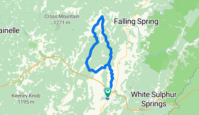
Rader's Valley
A cycling route starting in Lewisburg, West Virginia, United States.
Overview
About this route
Pleasant ride over rolling farmland. Mostly 1 lane, paved roads. Some truck traffic around a rock quarry on Unus Road and on US Route 60. Significant traffic at times on Fairview Road.
- -:--
- Duration
- 63.7 km
- Distance
- 532 m
- Ascent
- 517 m
- Descent
- ---
- Avg. speed
- ---
- Max. altitude
Route quality
Waytypes & surfaces along the route
Waytypes
Quiet road
35.7 km
(56 %)
Road
26.1 km
(41 %)
Undefined
1.9 km
(3 %)
Surfaces
Unpaved
0.6 km
(1 %)
Unpaved (undefined)
0.6 km
(1 %)
Undefined
63 km
(99 %)
Continue with Bikemap
Use, edit, or download this cycling route
You would like to ride Rader's Valley or customize it for your own trip? Here is what you can do with this Bikemap route:
Free features
- Save this route as favorite or in collections
- Copy & plan your own version of this route
- Sync your route with Garmin or Wahoo
Premium features
Free trial for 3 days, or one-time payment. More about Bikemap Premium.
- Navigate this route on iOS & Android
- Export a GPX / KML file of this route
- Create your custom printout (try it for free)
- Download this route for offline navigation
Discover more Premium features.
Get Bikemap PremiumFrom our community
Other popular routes starting in Lewisburg
 ms150?
- Distance
- 114.4 km
- Ascent
- 1,535 m
- Descent
- 1,461 m
- Location
- Lewisburg, West Virginia, United States
 WOH 18 Mile Garter
- Distance
- 28.4 km
- Ascent
- 203 m
- Descent
- 203 m
- Location
- Lewisburg, West Virginia, United States
 Lewisburg, Blue Sulphur Springs - Option B - Lewisburg, Blue Sulphur Springs - Option B
- Distance
- 80 km
- Ascent
- 1,912 m
- Descent
- 1,915 m
- Location
- Lewisburg, West Virginia, United States
 Williamsburg Loop
- Distance
- 76.8 km
- Ascent
- 636 m
- Descent
- 636 m
- Location
- Lewisburg, West Virginia, United States
 Restful route in
- Distance
- 18.4 km
- Ascent
- 232 m
- Descent
- 234 m
- Location
- Lewisburg, West Virginia, United States
 Unis Loop
- Distance
- 62.3 km
- Ascent
- 630 m
- Descent
- 630 m
- Location
- Lewisburg, West Virginia, United States
 Lewisburg, Blue Sulphur Springs
- Distance
- 75.7 km
- Ascent
- 892 m
- Descent
- 892 m
- Location
- Lewisburg, West Virginia, United States
 Unis Loop 1
- Distance
- 57.9 km
- Ascent
- 373 m
- Descent
- 373 m
- Location
- Lewisburg, West Virginia, United States
Open it in the app