

Reichraming zu den Schleierfällen
A cycling route starting in Reichraming, Upper Austria, Austria.
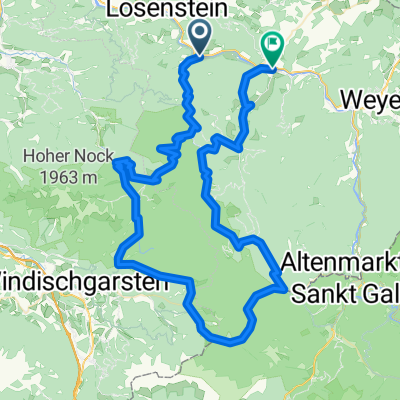
Overview
About this route
A beautiful ride into the backcountry along the route of the former forest railway used for timber transport.
The road is paved at first, then a good gravel road. There are no steep climbs. The peaks shown in the elevation profile do not exist. The road goes through tunnels there, which the GPS does not detect.
- -:--
- Duration
- 20.2 km
- Distance
- 558 m
- Ascent
- 299 m
- Descent
- ---
- Avg. speed
- ---
- Max. altitude
Route quality
Waytypes & surfaces along the route
Waytypes
Track
14.5 km
(72 %)
Road
5.6 km
(28 %)
Surfaces
Paved
0.8 km
(4 %)
Unpaved
13.5 km
(67 %)
Gravel
13.5 km
(67 %)
Paved (undefined)
0.8 km
(4 %)
Undefined
5.9 km
(29 %)
Route highlights
Points of interest along the route
Point of interest after 0 km
Fahradverleih in Reichraming
Point of interest after 5.7 km
Parkplatz Anzenbach, kann auch von Brunnbach über die Anzenbacher Bezirksstraße erreicht werden. Fußmarsch von hier zur Großen Klaushütte ca. 1,5 Std. (flach)
Accommodation after 13.1 km
Gasthaus "Große Klaushütte" in der Nähe der Grossen Klause, der einst mächtigsten Klause im Hintergebirge. Zu Fuß v. Brunnbach über d. Kreuzweg max. 2 Std. Zu Fuß vom Parkplatz Anzenbach ca. 1,5 Std. (flach) Per Rad von Reichraming ca. 1 Std (ca. 13 Km - gering ansteigend)
Point of interest after 13.1 km
Brunnbach
Point of interest after 17.1 km
Beginn des "Trifftsteiges" (ca. 17 Km) Ein gut gesicherter "Klettersteig", der dem geschlungenen, tief eingeschnittenen Flusslauf folgt. Gehzeit ca. 1,25 Std. Der Weg zurück kann auf der Straße durch insges. 5 Tunnel, in rd. 30 min. zurückgelegt werden. Ein schönes Erlebnis - Trittsicherheit u. keine Höhenangst sind notwendig
Point of interest after 18.2 km
Ende des "Trittsteiges". Rückweg durch die Tunnel, zurück zu den Rädern. Die Tunnel sind durch Solarstrom geringfügig erleuchtet. Eine Taschenlampe pro Gruppe wäre sicherheitshalber von Vorteil, wenn auch nicht unbedingt notwendig
Point of interest after 18.2 km
Point of interest after 19.2 km
"Schleierfall" - Wasserfall, der schleierartig über eine große Höhe herunterfällt. (ganz nett)
Point of interest after 20.2 km
Point of interest after 20.2 km
Point of interest after 20.2 km
Point of interest after 20.2 km
Continue with Bikemap
Use, edit, or download this cycling route
You would like to ride Reichraming zu den Schleierfällen or customize it for your own trip? Here is what you can do with this Bikemap route:
Free features
- Save this route as favorite or in collections
- Copy & plan your own version of this route
- Sync your route with Garmin or Wahoo
Premium features
Free trial for 3 days, or one-time payment. More about Bikemap Premium.
- Navigate this route on iOS & Android
- Export a GPX / KML file of this route
- Create your custom printout (try it for free)
- Download this route for offline navigation
Discover more Premium features.
Get Bikemap PremiumFrom our community
Other popular routes starting in Reichraming
 Molln /Schaunbergalm / Ebenforstalm
- Distance
- 33.1 km
- Ascent
- 1,034 m
- Descent
- 1,032 m
- Location
- Reichraming, Upper Austria, Austria
 Reichraming Ramble
- Distance
- 95.2 km
- Ascent
- 3,869 m
- Descent
- 3,842 m
- Location
- Reichraming, Upper Austria, Austria
 Breitenau, Ebenforstalm, Breitenau
- Distance
- 24.2 km
- Ascent
- 690 m
- Descent
- 683 m
- Location
- Reichraming, Upper Austria, Austria
 Reichraming Hintergebirge Anlaufalm
- Distance
- 47.7 km
- Ascent
- 2,264 m
- Descent
- 2,263 m
- Location
- Reichraming, Upper Austria, Austria
 Hintergebirgsradweg R9 Reichraming
- Distance
- 45.5 km
- Ascent
- 640 m
- Descent
- 664 m
- Location
- Reichraming, Upper Austria, Austria
 Hintergebirgsrunde
- Distance
- 36.1 km
- Ascent
- 1,059 m
- Descent
- 1,055 m
- Location
- Reichraming, Upper Austria, Austria
 Reichraming R9
- Distance
- 41.3 km
- Ascent
- 537 m
- Descent
- 521 m
- Location
- Reichraming, Upper Austria, Austria
 Reichraming zu den Schleierfällen
- Distance
- 20.2 km
- Ascent
- 558 m
- Descent
- 299 m
- Location
- Reichraming, Upper Austria, Austria
Open it in the app