

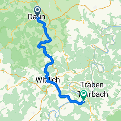
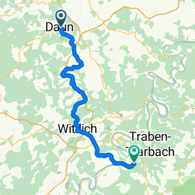
Maare-Mosel-Radweg
A cycling route starting in Daun, Rhineland-Palatinate, Germany.
Overview
About this route
Von Daun in der Südeifel geht es auf einer ehemaligen Bahntrasse bis hinunter an die Mosel. Der Radweg ist bestens ausgebaut. Highlights auf und an der Strecke sind die alten Eisenbahntunnel und die Lavabombe in Strohn. Auch ein Abstecher zu einem der Maare ist lohnenswert.
Wie kommt man nach Daun? Ab Bahnhof Wittlich-Wengerohr fährt ein Radelbus.
- -:--
- Duration
- 60.5 km
- Distance
- 281 m
- Ascent
- 519 m
- Descent
- ---
- Avg. speed
- ---
- Max. altitude

Route quality
Waytypes & surfaces along the route
Waytypes
Cycleway
34.7 km
(57 %)
Track
8 km
(13 %)
Surfaces
Paved
52.7 km
(87 %)
Unpaved
1.9 km
(3 %)
Asphalt
50.3 km
(83 %)
Gravel
1.8 km
(3 %)
Route highlights
Points of interest along the route
Point of interest after 2.8 km
Tunnel "Großes Schlitzohr"
Point of interest after 15.8 km
Lavabombe Strohn
Point of interest after 23.3 km
Bauernhofcafe
Point of interest after 38.2 km
Pleiner Tunnel
Point of interest after 56.5 km
Biergarten
Continue with Bikemap
Use, edit, or download this cycling route
You would like to ride Maare-Mosel-Radweg or customize it for your own trip? Here is what you can do with this Bikemap route:
Free features
- Save this route as favorite or in collections
- Copy & plan your own version of this route
- Sync your route with Garmin or Wahoo
Premium features
Free trial for 3 days, or one-time payment. More about Bikemap Premium.
- Navigate this route on iOS & Android
- Export a GPX / KML file of this route
- Create your custom printout (try it for free)
- Download this route for offline navigation
Discover more Premium features.
Get Bikemap PremiumFrom our community
Other popular routes starting in Daun
 Maare-Mosel-Radweg 090606
- Distance
- 58.2 km
- Ascent
- 370 m
- Descent
- 648 m
- Location
- Daun, Rhineland-Palatinate, Germany
 Pützborn-Schalkenmehren-Winkel-BadBertrich-Alf-Reil-Strotzbüsch-Gillenfeld-Gemünden-Pützborn
- Distance
- 108.1 km
- Ascent
- 940 m
- Descent
- 931 m
- Location
- Daun, Rhineland-Palatinate, Germany
 Maare-Mosel Radweg
- Distance
- 57.8 km
- Ascent
- 197 m
- Descent
- 469 m
- Location
- Daun, Rhineland-Palatinate, Germany
 Maare - Mosel
- Distance
- 59.8 km
- Ascent
- 254 m
- Descent
- 497 m
- Location
- Daun, Rhineland-Palatinate, Germany
 Maare - Mosel Bahntrasse
- Distance
- 59.7 km
- Ascent
- 400 m
- Descent
- 665 m
- Location
- Daun, Rhineland-Palatinate, Germany
 4 Krater Tour
- Distance
- 55.4 km
- Ascent
- 887 m
- Descent
- 874 m
- Location
- Daun, Rhineland-Palatinate, Germany
 Daun Vulkanenroute
- Distance
- 45 km
- Ascent
- 686 m
- Descent
- 686 m
- Location
- Daun, Rhineland-Palatinate, Germany
 Daun nach Bernkastel 2016
- Distance
- 57.6 km
- Ascent
- 386 m
- Descent
- 675 m
- Location
- Daun, Rhineland-Palatinate, Germany
Open it in the app