Wald - Tirsch
A cycling route starting in Waldsassen, Bavaria, Germany.
Overview
About this route
- -:--
- Duration
- 17.5 km
- Distance
- 146 m
- Ascent
- 135 m
- Descent
- ---
- Avg. speed
- ---
- Max. altitude
Route quality
Waytypes & surfaces along the route
Waytypes
Cycleway
8.4 km
(48 %)
Quiet road
4 km
(23 %)
Surfaces
Paved
15.7 km
(90 %)
Asphalt
14.7 km
(84 %)
Paved (undefined)
1 km
(6 %)
Undefined
1.7 km
(10 %)
Continue with Bikemap
Use, edit, or download this cycling route
You would like to ride Wald - Tirsch or customize it for your own trip? Here is what you can do with this Bikemap route:
Free features
- Save this route as favorite or in collections
- Copy & plan your own version of this route
- Sync your route with Garmin or Wahoo
Premium features
Free trial for 3 days, or one-time payment. More about Bikemap Premium.
- Navigate this route on iOS & Android
- Export a GPX / KML file of this route
- Create your custom printout (try it for free)
- Download this route for offline navigation
Discover more Premium features.
Get Bikemap PremiumFrom our community
Other popular routes starting in Waldsassen
- 2. Teil Furth i.Wald - Cossebaude
- Distance
- 133.9 km
- Ascent
- 1,768 m
- Descent
- 1,699 m
- Location
- Waldsassen, Bavaria, Germany
- Lange Radrunde durch Waldsassen
- Distance
- 58.1 km
- Ascent
- 478 m
- Descent
- 480 m
- Location
- Waldsassen, Bavaria, Germany
- Egergrabenradweg EGW
- Distance
- 79.2 km
- Ascent
- ---
- Descent
- ---
- Location
- Waldsassen, Bavaria, Germany
- 10.07.17 Konnersreuth-Adorf (6. Etappe)
- Distance
- 56.2 km
- Ascent
- 421 m
- Descent
- 543 m
- Location
- Waldsassen, Bavaria, Germany
- Rund um Mitterteich
- Distance
- 34 km
- Ascent
- 375 m
- Descent
- 381 m
- Location
- Waldsassen, Bavaria, Germany
- Kleine Heimtarunde
- Distance
- 32 km
- Ascent
- 437 m
- Descent
- 438 m
- Location
- Waldsassen, Bavaria, Germany
- Wald - Tirsch
- Distance
- 17.5 km
- Ascent
- 146 m
- Descent
- 135 m
- Location
- Waldsassen, Bavaria, Germany
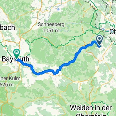
- Wallensteinradweg - Mühlenradweg
- Distance
- 62.1 km
- Ascent
- 636 m
- Descent
- 623 m
- Location
- Waldsassen, Bavaria, Germany
Open it in the app