

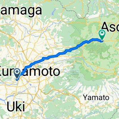
Day 527
A cycling route starting in Kumamoto, Kumamoto, Japan.
Overview
About this route
- -:--
- Duration
- 4.9 km
- Distance
- 3 m
- Ascent
- 11 m
- Descent
- ---
- Avg. speed
- 24 m
- Max. altitude

Continue with Bikemap
Use, edit, or download this cycling route
You would like to ride Day 527 or customize it for your own trip? Here is what you can do with this Bikemap route:
Free features
- Save this route as favorite or in collections
- Copy & plan your own version of this route
- Sync your route with Garmin or Wahoo
Premium features
Free trial for 3 days, or one-time payment. More about Bikemap Premium.
- Navigate this route on iOS & Android
- Export a GPX / KML file of this route
- Create your custom printout (try it for free)
- Download this route for offline navigation
Discover more Premium features.
Get Bikemap PremiumFrom our community
Other popular routes starting in Kumamoto
 Aso day 1
- Distance
- 50.2 km
- Ascent
- 941 m
- Descent
- 421 m
- Location
- Kumamoto, Kumamoto, Japan
 kyushu day4
- Distance
- 54.4 km
- Ascent
- 125 m
- Descent
- 138 m
- Location
- Kumamoto, Kumamoto, Japan
 9-39, Jozanhanta 2-Chōme, Nishi, Kumamoto to 1963-2, Sakamoto, Misato, Shimomashiki-Gun
- Distance
- 35.9 km
- Ascent
- 442 m
- Descent
- 188 m
- Location
- Kumamoto, Kumamoto, Japan
 Day 524
- Distance
- 38.5 km
- Ascent
- 478 m
- Descent
- 100 m
- Location
- Kumamoto, Kumamoto, Japan
 Kumamoto to Kagoshima
- Distance
- 224.6 km
- Ascent
- 4,275 m
- Descent
- 4,275 m
- Location
- Kumamoto, Kumamoto, Japan
 Kumamoto-Aso
- Distance
- 46.7 km
- Ascent
- 1,218 m
- Descent
- 89 m
- Location
- Kumamoto, Kumamoto, Japan
 Kasuga 3-Chōme, Kumamoto to Jinnai, Ozu
- Distance
- 22.3 km
- Ascent
- 170 m
- Descent
- 80 m
- Location
- Kumamoto, Kumamoto, Japan
 千原台高校自転車競技部推薦コース
- Distance
- 24 km
- Ascent
- 0 m
- Descent
- 0 m
- Location
- Kumamoto, Kumamoto, Japan
Open it in the app