

Melkhus Fintel
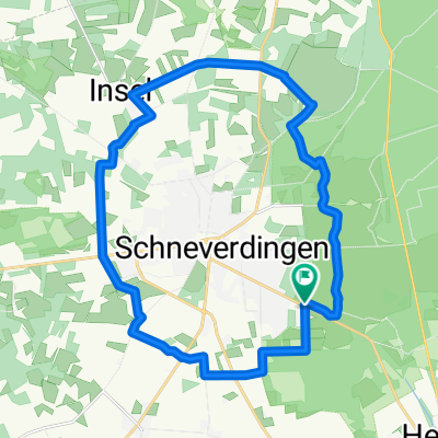
A cycling route starting in Schneverdingen, Lower Saxony, Germany.
Overview
About this route
Schöne Tour, auf ruhigen Straßen, > 90% Aspalt
- -:--
- Duration
- 28 km
- Distance
- 58 m
- Ascent
- 55 m
- Descent
- ---
- Avg. speed
- ---
- Max. altitude

Route quality
Waytypes & surfaces along the route
Waytypes
Quiet road
16.5 km
(59 %)
Road
6.7 km
(24 %)
Surfaces
Paved
19.8 km
(71 %)
Unpaved
0.7 km
(2 %)
Asphalt
18.1 km
(64 %)
Paved (undefined)
1.5 km
(5 %)
Continue with Bikemap
Use, edit, or download this cycling route
You would like to ride Melkhus Fintel or customize it for your own trip? Here is what you can do with this Bikemap route:
Free features
- Save this route as favorite or in collections
- Copy & plan your own version of this route
- Sync your route with Garmin or Wahoo
Premium features
Free trial for 3 days, or one-time payment. More about Bikemap Premium.
- Navigate this route on iOS & Android
- Export a GPX / KML file of this route
- Create your custom printout (try it for free)
- Download this route for offline navigation
Discover more Premium features.
Get Bikemap PremiumFrom our community
Other popular routes starting in Schneverdingen
 4_TourRundumSchneverdingen
- Distance
- 22.3 km
- Ascent
- 76 m
- Descent
- 76 m
- Location
- Schneverdingen, Lower Saxony, Germany
 Heiderunde - Start an der KGS Schneverdingen
- Distance
- 28.7 km
- Ascent
- 100 m
- Descent
- 100 m
- Location
- Schneverdingen, Lower Saxony, Germany
 13.10.13
- Distance
- 43.5 km
- Ascent
- 216 m
- Descent
- 218 m
- Location
- Schneverdingen, Lower Saxony, Germany
 Durch die Heide
- Distance
- 42.1 km
- Ascent
- 182 m
- Descent
- 180 m
- Location
- Schneverdingen, Lower Saxony, Germany
 Tag 4Schneverdingen-Höpen-Forst
- Distance
- 29.1 km
- Ascent
- 90 m
- Descent
- 90 m
- Location
- Schneverdingen, Lower Saxony, Germany
 02-Schneverdingen-Hitzacker-102km
- Distance
- 101.3 km
- Ascent
- 608 m
- Descent
- 679 m
- Location
- Schneverdingen, Lower Saxony, Germany
 heide
heide- Distance
- 47.5 km
- Ascent
- 192 m
- Descent
- 191 m
- Location
- Schneverdingen, Lower Saxony, Germany
 Rund um Schneverdingen
- Distance
- 45.1 km
- Ascent
- 91 m
- Descent
- 90 m
- Location
- Schneverdingen, Lower Saxony, Germany
Open it in the app