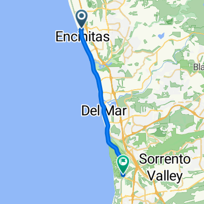
Beach Ride
A cycling route starting in Encinitas, California, United States of America.
Overview
About this route
- -:--
- Duration
- 58.3 km
- Distance
- 537 m
- Ascent
- 537 m
- Descent
- ---
- Avg. speed
- ---
- Avg. speed
Route quality
Waytypes & surfaces along the route
Waytypes
Busy road
37.6 km
(65 %)
Cycleway
8.4 km
(14 %)
Surfaces
Paved
22.6 km
(39 %)
Asphalt
22.2 km
(38 %)
Concrete
0.4 km
(<1 %)
Undefined
35.7 km
(61 %)
Continue with Bikemap
Use, edit, or download this cycling route
You would like to ride Beach Ride or customize it for your own trip? Here is what you can do with this Bikemap route:
Free features
- Save this route as favorite or in collections
- Copy & plan your own version of this route
- Sync your route with Garmin or Wahoo
Premium features
Free trial for 3 days, or one-time payment. More about Bikemap Premium.
- Navigate this route on iOS & Android
- Export a GPX / KML file of this route
- Create your custom printout (try it for free)
- Download this route for offline navigation
Discover more Premium features.
Get Bikemap PremiumFrom our community
Other popular routes starting in Encinitas
- 14 - Carlsbad to San Diego
- Distance
- 47.1 km
- Ascent
- 308 m
- Descent
- 324 m
- Location
- Encinitas, California, United States of America
- WPC Saturday Social Ride
- Distance
- 97.8 km
- Ascent
- 859 m
- Descent
- 861 m
- Location
- Encinitas, California, United States of America
- Beach Ride
- Distance
- 58.3 km
- Ascent
- 537 m
- Descent
- 537 m
- Location
- Encinitas, California, United States of America
- 7200 Ponto Dr, Carlsbad to 8800 Lombard Pl, San Diego
- Distance
- 29.7 km
- Ascent
- 289 m
- Descent
- 197 m
- Location
- Encinitas, California, United States of America
- Swamis
- Distance
- 62.2 km
- Ascent
- 551 m
- Descent
- 551 m
- Location
- Encinitas, California, United States of America
- Route from 566 S Coast Hwy 101, Encinitas
- Distance
- 33.6 km
- Ascent
- 23 m
- Descent
- 46 m
- Location
- Encinitas, California, United States of America
- Short and easy solo
- Distance
- 46.3 km
- Ascent
- 387 m
- Descent
- 372 m
- Location
- Encinitas, California, United States of America
- Ausfahrt, ca 3,5h
- Distance
- 78.4 km
- Ascent
- 478 m
- Descent
- 522 m
- Location
- Encinitas, California, United States of America
Open it in the app