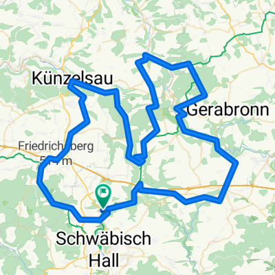
Untermünkeim - Kochertal - Waldenburg Rennrad
A cycling route starting in Untermünkheim, Baden-Wurttemberg, Germany.
Overview
About this route
Very beautiful route along the Kochertalradweg to Künzelsau, then from Künzelsau on the perfectly developed cycle path to Waldenburg station on the former railway line.
- -:--
- Duration
- 48.1 km
- Distance
- 313 m
- Ascent
- 313 m
- Descent
- ---
- Avg. speed
- ---
- Max. altitude
Route quality
Waytypes & surfaces along the route
Waytypes
Track
21.1 km
(44 %)
Path
11.5 km
(24 %)
Surfaces
Paved
42.3 km
(88 %)
Unpaved
0.5 km
(1 %)
Asphalt
42.3 km
(88 %)
Gravel
0.5 km
(1 %)
Undefined
5.3 km
(11 %)
Continue with Bikemap
Use, edit, or download this cycling route
You would like to ride Untermünkeim - Kochertal - Waldenburg Rennrad or customize it for your own trip? Here is what you can do with this Bikemap route:
Free features
- Save this route as favorite or in collections
- Copy & plan your own version of this route
- Sync your route with Garmin or Wahoo
Premium features
Free trial for 3 days, or one-time payment. More about Bikemap Premium.
- Navigate this route on iOS & Android
- Export a GPX / KML file of this route
- Create your custom printout (try it for free)
- Download this route for offline navigation
Discover more Premium features.
Get Bikemap PremiumFrom our community
Other popular routes starting in Untermünkheim
Kochertal Aalen - Schwäbisch Hall - Bad Friedrichsau Tag 2- Distance
- 73.8 km
- Ascent
- 683 m
- Descent
- 784 m
- Location
- Untermünkheim, Baden-Wurttemberg, Germany
Untermünkheim - Ilshofen - Langenburg - Waldenburg ...- Distance
- 112.8 km
- Ascent
- 971 m
- Descent
- 972 m
- Location
- Untermünkheim, Baden-Wurttemberg, Germany
Untermünkeim - Bühlertal - Tüngental Rennrad- Distance
- 31.9 km
- Ascent
- 331 m
- Descent
- 329 m
- Location
- Untermünkheim, Baden-Wurttemberg, Germany
Bühlerbachrunde bei Schwäbisch Hall- Distance
- 38.3 km
- Ascent
- 458 m
- Descent
- 456 m
- Location
- Untermünkheim, Baden-Wurttemberg, Germany
OMH - Starkh.b. - Bubeno. - Mittelsteinach - Neumühlsee - OMH- Distance
- 44.4 km
- Ascent
- 608 m
- Descent
- 609 m
- Location
- Untermünkheim, Baden-Wurttemberg, Germany
Schwäbisch Hall - Langenburg - Waldenburg - S.H.- Distance
- 109.4 km
- Ascent
- 967 m
- Descent
- 968 m
- Location
- Untermünkheim, Baden-Wurttemberg, Germany
Auf dem Weg nach Wertheim- Distance
- 101.9 km
- Ascent
- 464 m
- Descent
- 576 m
- Location
- Untermünkheim, Baden-Wurttemberg, Germany
Untermünkeim - Kochertal - Waldenburg Rennrad- Distance
- 48.1 km
- Ascent
- 313 m
- Descent
- 313 m
- Location
- Untermünkheim, Baden-Wurttemberg, Germany
Open it in the app

