

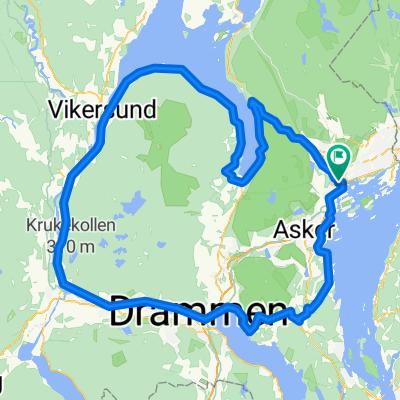
Rundtur i Lommedalen
A cycling route starting in Sandvika, Akershus, Norway.
Overview
About this route
Fra Haslum til Øvre Jonsrud gård følger en "Pilgrimsleden". Deretter fant jeg en rute til Mattisplassveien som jeg fulgte til brua over Tverrelva. Retur via By og Kolsås
- -:--
- Duration
- 40.9 km
- Distance
- 452 m
- Ascent
- 452 m
- Descent
- ---
- Avg. speed
- ---
- Max. altitude

Route quality
Waytypes & surfaces along the route
Waytypes
Quiet road
18.4 km
(45 %)
Cycleway
9.8 km
(24 %)
Surfaces
Paved
17.6 km
(43 %)
Unpaved
12.7 km
(31 %)
Asphalt
17.6 km
(43 %)
Gravel
12.7 km
(31 %)
Undefined
10.6 km
(26 %)
Continue with Bikemap
Use, edit, or download this cycling route
You would like to ride Rundtur i Lommedalen or customize it for your own trip? Here is what you can do with this Bikemap route:
Free features
- Save this route as favorite or in collections
- Copy & plan your own version of this route
- Sync your route with Garmin or Wahoo
Premium features
Free trial for 3 days, or one-time payment. More about Bikemap Premium.
- Navigate this route on iOS & Android
- Export a GPX / KML file of this route
- Create your custom printout (try it for free)
- Download this route for offline navigation
Discover more Premium features.
Get Bikemap PremiumFrom our community
Other popular routes starting in Sandvika
 sandvika slemmestad hvalstad blommeholm
- Distance
- 49.9 km
- Ascent
- 486 m
- Descent
- 485 m
- Location
- Sandvika, Akershus, Norway
 Rundtur i Lommedalen
- Distance
- 40.9 km
- Ascent
- 452 m
- Descent
- 452 m
- Location
- Sandvika, Akershus, Norway
 Slemmestad - Heggedal - Dikemark - Asker
- Distance
- 48.2 km
- Ascent
- 455 m
- Descent
- 454 m
- Location
- Sandvika, Akershus, Norway
 Sandviksveien, Sandvika to Trelastgata 7, Oslo
- Distance
- 17.7 km
- Ascent
- 6 m
- Descent
- 16 m
- Location
- Sandvika, Akershus, Norway
 New Sandvika-Tjuvholmen
- Distance
- 13.3 km
- Ascent
- 91 m
- Descent
- 97 m
- Location
- Sandvika, Akershus, Norway
 Haslum-Sjølyst-Røa-Bekkestua-Haslum
- Distance
- 23.6 km
- Ascent
- 274 m
- Descent
- 274 m
- Location
- Sandvika, Akershus, Norway
 Treningsrunden via Eiker og Sylling
- Distance
- 144.6 km
- Ascent
- 722 m
- Descent
- 723 m
- Location
- Sandvika, Akershus, Norway
 Vestmarka rundt Store Sandungen
- Distance
- 43 km
- Ascent
- 590 m
- Descent
- 590 m
- Location
- Sandvika, Akershus, Norway
Open it in the app