

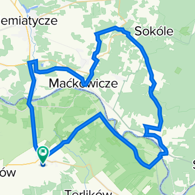
Mielnik - Koterka - Grabarka
A cycling route starting in Sarnaki, Masovian Voivodeship, Poland.
Overview
About this route
A pleasant Sunday ride through picturesque surroundings. Along the route there are several interesting places worth visiting.
- -:--
- Duration
- 55.3 km
- Distance
- 163 m
- Ascent
- 163 m
- Descent
- ---
- Avg. speed
- ---
- Max. altitude

Route quality
Waytypes & surfaces along the route
Waytypes
Road
25.5 km
(46 %)
Quiet road
18.3 km
(33 %)
Surfaces
Paved
39.3 km
(71 %)
Unpaved
3.9 km
(7 %)
Asphalt
39.3 km
(71 %)
Gravel
1.7 km
(3 %)
Route highlights
Points of interest along the route
Point of interest after 0.6 km
Point of interest after 8.1 km
Potężne zbiorniki ropy przy rurociągu "Przyjaźń"
Point of interest after 22.4 km
Do samej granicy jedziemy wzdłuż rurociągu "Przyjaźń".
Point of interest after 25.6 km
Do Radziwiłłówki jedziemy wzdłuż rurociągu "Przyjaźń"
Point of interest after 32.2 km
Stąd, aż do Grabarki jedziemy nową drogą asfaltową, której jeszcze nie ma na mapach
Point of interest after 45 km
Wzdłuż Bugu bunkry dawnej linii umocnień zwanej "Linią Mołotowa"
Point of interest after 49.4 km
Tu zaczyna się nowa ścieżka rowerowa nie uwidoczniona na mapach (ubity żwir), która kończy się w Mielniku
Continue with Bikemap
Use, edit, or download this cycling route
You would like to ride Mielnik - Koterka - Grabarka or customize it for your own trip? Here is what you can do with this Bikemap route:
Free features
- Save this route as favorite or in collections
- Copy & plan your own version of this route
- Sync your route with Garmin or Wahoo
Premium features
Free trial for 3 days, or one-time payment. More about Bikemap Premium.
- Navigate this route on iOS & Android
- Export a GPX / KML file of this route
- Create your custom printout (try it for free)
- Download this route for offline navigation
Discover more Premium features.
Get Bikemap PremiumFrom our community
Other popular routes starting in Sarnaki
 (6) Mielnik-Janów Podlaski-Terespol-Sławatycze
- Distance
- 122 km
- Ascent
- 176 m
- Descent
- 160 m
- Location
- Sarnaki, Masovian Voivodeship, Poland
 Sarnaki - Podlaski przełom Bugu
- Distance
- 57.2 km
- Ascent
- 433 m
- Descent
- 434 m
- Location
- Sarnaki, Masovian Voivodeship, Poland
 Wycieczka Nr 26/2013 – Park Krajobrazowy „Podlaski Przełom Bugu” - 11-15 września
- Distance
- 77.3 km
- Ascent
- 229 m
- Descent
- 229 m
- Location
- Sarnaki, Masovian Voivodeship, Poland
 Pierwsza Nadbużańska Przechadzka Po Podlasiu - pomagamy Rycerzowi Mikołajowi.
- Distance
- 17.2 km
- Ascent
- 189 m
- Descent
- 215 m
- Location
- Sarnaki, Masovian Voivodeship, Poland
 Podlasie2
- Distance
- 60.4 km
- Ascent
- 176 m
- Descent
- 138 m
- Location
- Sarnaki, Masovian Voivodeship, Poland
 Podlasie 2019
- Distance
- 192 km
- Ascent
- 302 m
- Descent
- 301 m
- Location
- Sarnaki, Masovian Voivodeship, Poland
 Wycieczka Nr 26/2013 – Park Krajobrazowy „Podlaski Przełom Bugu” - 11-15 września
- Distance
- 62.4 km
- Ascent
- 189 m
- Descent
- 188 m
- Location
- Sarnaki, Masovian Voivodeship, Poland
 7 dzień MIELNIK - HAJNÓWKA GVelo
- Distance
- 90.2 km
- Ascent
- 215 m
- Descent
- 176 m
- Location
- Sarnaki, Masovian Voivodeship, Poland
Open it in the app