- 27.3 km
- 369 m
- 495 m
- Schramberg, Baden-Wurttemberg, Germany
Leichtere Tour von Trumpf Laser Sulgen nach Weingut Müller Herztal
A cycling route starting in Schramberg, Baden-Wurttemberg, Germany.
Overview
About this route
Varied route with downhill descent from Aichhalden to Schiltach. Along the Kinzig until Ohlsbach. We follow the Ohlsbach valley for about 6 km until Ritterberg and further until Hohenberg. From there, we go along the Durchbach to the town of the same name (about 5 km). After a small stop, we continue on the Ortenau Wine Trail to Illental and from there towards Oppenau. However, we do not go into the town but to the Wendelkappelle. From there, we cycle a few hundred meters downhill to Herztal, where just at the entrance of the village we are warmly welcomed by the Herztal winery, with Ulrike and Hubert Müller. Have fun!
- -:--
- Duration
- 75.2 km
- Distance
- 758 m
- Ascent
- 1,263 m
- Descent
- ---
- Avg. speed
- ---
- Max. altitude
created this 16 years ago
Continue with Bikemap
Use, edit, or download this cycling route
You would like to ride Leichtere Tour von Trumpf Laser Sulgen nach Weingut Müller Herztal or customize it for your own trip? Here is what you can do with this Bikemap route:
Free features
- Save this route as favorite or in collections
- Copy & plan your own version of this route
- Sync your route with Garmin or Wahoo
Premium features
Free trial for 3 days, or one-time payment. More about Bikemap Premium.
- Navigate this route on iOS & Android
- Export a GPX / KML file of this route
- Create your custom printout (try it for free)
- Download this route for offline navigation
Discover more Premium features.
Get Bikemap PremiumFrom our community
Other popular routes starting in Schramberg
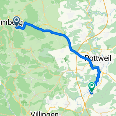
- От Schorenweg до Scheibenbühlweg
- MTB_Fohb-Lfb-Schbg-RW-Schilt
- 23.9 km
- 583 m
- 527 m
- Schramberg, Baden-Wurttemberg, Germany
- Verano 26 . 10
- 74.5 km
- 1,144 m
- 1,145 m
- Schramberg, Baden-Wurttemberg, Germany
- Welzheim-Schwarzwald 4.Tag
- 211.7 km
- 2,474 m
- 2,454 m
- Schramberg, Baden-Wurttemberg, Germany
- Schramberg-Aichhalden-Schenkenzell-Schiltach-Schramberg
- 32.3 km
- 469 m
- 475 m
- Schramberg, Baden-Wurttemberg, Germany
- Sulgen "Römerweg 1" Sulgen
- 45.6 km
- 324 m
- 345 m
- Schramberg, Baden-Wurttemberg, Germany
- Rund um Schramberg
- 113.8 km
- 4,885 m
- 4,633 m
- Schramberg, Baden-Wurttemberg, Germany
- Leichtere Tour von Trumpf Laser Sulgen nach Weingut Müller Herztal
- 75.2 km
- 758 m
- 1,263 m
- Schramberg, Baden-Wurttemberg, Germany
Open it in the app


