

Ahr Radweg
A cycling route starting in Blankenheim, North Rhine-Westphalia, Germany.
Overview
About this route
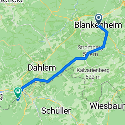
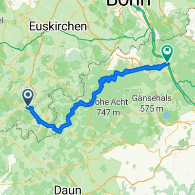
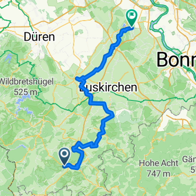
The starting signal for the tour from the Eifel to the Rhine is given in the small Ahr town of Blankenheim. Here, the Ahr river springs to life in the historic town center under a house. The bike path initially follows the Ahr through the natural experience area Oberes Ahtal, a peaceful valley landscape with wide river meanders. Thrilling heights are experienced when riding over the old aqueduct at Oberahreck and along the former Ahr valley railway routes. In total, nine bridge structures are crossed over the 17 kilometers to Ahrdorf. The Ahr valley narrows for the first time at the village of Schuld, which is picturesquely nestled in an Ahr loop. Then the valley widens again before, from Kreuzberg, rocks and slopes move close to the Ahr, providing ideal conditions for viticulture. The Ahr bike path immerses itself in the refined world of spa treatment in Bad Neuenahr-Ahrweiler. Up to the Rhine, it has only one last rocky narrow passage to master along with the Ahr before reaching the wide delta at the mouth.
- -:--
- Duration
- 80.4 km
- Distance
- 146 m
- Ascent
- 576 m
- Descent
- ---
- Avg. speed
- ---
- Max. altitude
Route highlights
Points of interest along the route
Photo after 4.9 km
Ahr-Quelle
Point of interest after 47.1 km
VRS Bahnhof Ahrbrück Verbindung nach Bonn Erster Bf von Blankenheim kommend
Point of interest after 65.8 km
VRS Bahnhof Ahrweiler Markt Verbindung nach Bonn
Point of interest after 66.2 km
Abzweigung zum VRS Bahnhof Ahrweiler Markt
Continue with Bikemap
Use, edit, or download this cycling route
You would like to ride Ahr Radweg or customize it for your own trip? Here is what you can do with this Bikemap route:
Free features
- Save this route as favorite or in collections
- Copy & plan your own version of this route
- Split it into stages to create a multi-day tour
- Sync your route with Garmin or Wahoo
Premium features
Free trial for 3 days, or one-time payment. More about Bikemap Premium.
- Navigate this route on iOS & Android
- Export a GPX / KML file of this route
- Create your custom printout (try it for free)
- Download this route for offline navigation
Discover more Premium features.
Get Bikemap PremiumFrom our community
Other popular routes starting in Blankenheim
 9_ Blankenheim bis Kerschenbach
- Distance
- 18.1 km
- Ascent
- 289 m
- Descent
- 241 m
- Location
- Blankenheim, North Rhine-Westphalia, Germany
 Vulkaneifelrunde
- Distance
- 84.3 km
- Ascent
- 820 m
- Descent
- 820 m
- Location
- Blankenheim, North Rhine-Westphalia, Germany
 Tour de Natur (Nordeifel)
- Distance
- 53.4 km
- Ascent
- 105 m
- Descent
- 484 m
- Location
- Blankenheim, North Rhine-Westphalia, Germany
 Ahr-Radweg
- Distance
- 131.3 km
- Ascent
- 1,695 m
- Descent
- 2,120 m
- Location
- Blankenheim, North Rhine-Westphalia, Germany
 Blankenheim, Nettersheim, Bad münster, Satzvey, Zülpich, Erftstadt, Brühl
- Distance
- 97.5 km
- Ascent
- 877 m
- Descent
- 1,298 m
- Location
- Blankenheim, North Rhine-Westphalia, Germany
 Ahr Radweg
- Distance
- 80.4 km
- Ascent
- 146 m
- Descent
- 576 m
- Location
- Blankenheim, North Rhine-Westphalia, Germany
 Am Freilinger See nach K69
- Distance
- 19.8 km
- Ascent
- 256 m
- Descent
- 277 m
- Location
- Blankenheim, North Rhine-Westphalia, Germany
 18 Ahrtalradroute
- Distance
- 85 km
- Ascent
- 87 m
- Descent
- 519 m
- Location
- Blankenheim, North Rhine-Westphalia, Germany
Open it in the app