

Ghotbi - løypa
A cycling route starting in Gjøvik, Oppland, Norway.
Overview
About this route
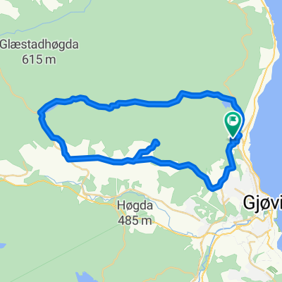
1. tredjedel av løypa (0-14 km): er langsmed Rv 33 med utsikt utover Mjøsa. Denne delen ender etter en lengre stigning der veien har dobbeltfil. Istedenfor å fortsette ned mot Lena, svinger du til venstre på toppen av stigningen.
- tredjedel (14-23 km): løper stort sett gjennom boligområder og har flere, kortere stigninger. Ender ved Nye Totenveg. (Alternativt kan du etter ca 20 km svinge mot høyre og inn i en grusvei, hvis du ikke ønsker å kjøre kun på asfalt).
Siste tredjedel (23-35 km): består stort sett i nedoverbakker, med flott utsikt over byen, og er en behagelig avslutning på turen:)
- -:--
- Duration
- 34.3 km
- Distance
- 567 m
- Ascent
- 567 m
- Descent
- ---
- Avg. speed
- ---
- Max. altitude
Continue with Bikemap
Use, edit, or download this cycling route
You would like to ride Ghotbi - løypa or customize it for your own trip? Here is what you can do with this Bikemap route:
Free features
- Save this route as favorite or in collections
- Copy & plan your own version of this route
- Sync your route with Garmin or Wahoo
Premium features
Free trial for 3 days, or one-time payment. More about Bikemap Premium.
- Navigate this route on iOS & Android
- Export a GPX / KML file of this route
- Create your custom printout (try it for free)
- Download this route for offline navigation
Discover more Premium features.
Get Bikemap PremiumFrom our community
Other popular routes starting in Gjøvik
 13.08.15 bike route
- Distance
- 37.7 km
- Ascent
- 566 m
- Descent
- 566 m
- Location
- Gjøvik, Oppland, Norway
 De Storgata 3-7 à Vaskerelven 16
- Distance
- 696.3 km
- Ascent
- 12,405 m
- Descent
- 12,526 m
- Location
- Gjøvik, Oppland, Norway
 Tour of Norway 2016 - Gjøvik - Beitostølen
- Distance
- 164.3 km
- Ascent
- 2,478 m
- Descent
- 1,705 m
- Location
- Gjøvik, Oppland, Norway
 Pres Skistuu a Overby
- Distance
- 28.9 km
- Ascent
- 0 m
- Descent
- 0 m
- Location
- Gjøvik, Oppland, Norway
 Vikenstranda 5, Gjøvik to Vikenstranda 47, Gjøvik
- Distance
- 28.7 km
- Ascent
- 602 m
- Descent
- 610 m
- Location
- Gjøvik, Oppland, Norway
 Bilitt-tur
- Distance
- 44 km
- Ascent
- 841 m
- Descent
- 841 m
- Location
- Gjøvik, Oppland, Norway
 Mjøstråkk 2
- Distance
- 158.8 km
- Ascent
- 661 m
- Descent
- 644 m
- Location
- Gjøvik, Oppland, Norway
 Ghotbi - løypa
- Distance
- 34.3 km
- Ascent
- 567 m
- Descent
- 567 m
- Location
- Gjøvik, Oppland, Norway
Open it in the app