

Tour de Picardie 2012 Stage 1
A cycling route starting in Clermont, Hauts-de-France, France.
Overview
About this route
- -:--
- Duration
- 168.5 km
- Distance
- 680 m
- Ascent
- 724 m
- Descent
- ---
- Avg. speed
- ---
- Max. altitude

Route quality
Waytypes & surfaces along the route
Waytypes
Road
88.9 km
(53 %)
Busy road
68.8 km
(41 %)
Surfaces
Paved
30.4 km
(18 %)
Unpaved
0.4 km
(<1 %)
Asphalt
30 km
(18 %)
Paved (undefined)
0.4 km
(<1 %)
Route highlights
Points of interest along the route
Point of interest after 40.4 km
Côte de Mareuil-la-Motte
Point of interest after 69.6 km
BRÉTIGNY Sprint
Point of interest after 91.1 km
Côte de Coucy-le-Château-Auffrique
Point of interest after 106.1 km
Côte de Vaudesson
Point of interest after 134.4 km
Entrée du circuit
Continue with Bikemap
Use, edit, or download this cycling route
You would like to ride Tour de Picardie 2012 Stage 1 or customize it for your own trip? Here is what you can do with this Bikemap route:
Free features
- Save this route as favorite or in collections
- Copy & plan your own version of this route
- Split it into stages to create a multi-day tour
- Sync your route with Garmin or Wahoo
Premium features
Free trial for 3 days, or one-time payment. More about Bikemap Premium.
- Navigate this route on iOS & Android
- Export a GPX / KML file of this route
- Create your custom printout (try it for free)
- Download this route for offline navigation
Discover more Premium features.
Get Bikemap PremiumFrom our community
Other popular routes starting in Clermont
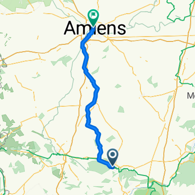 Clermont - Amiens
- Distance
- 78 km
- Ascent
- 697 m
- Descent
- 759 m
- Location
- Clermont, Hauts-de-France, France
 De Rue Pierre Vienot à Avenue du Maréchal Joffre
- Distance
- 29 km
- Ascent
- 192 m
- Descent
- 270 m
- Location
- Clermont, Hauts-de-France, France
 Tour de Picardie 2012 Stage 1
- Distance
- 168.5 km
- Ascent
- 680 m
- Descent
- 724 m
- Location
- Clermont, Hauts-de-France, France
 De Rue Pierre Vienot 134, Clermont à Rouen
- Distance
- 112.9 km
- Ascent
- 744 m
- Descent
- 836 m
- Location
- Clermont, Hauts-de-France, France
 2° giorno
- Distance
- 70.1 km
- Ascent
- 234 m
- Descent
- 215 m
- Location
- Clermont, Hauts-de-France, France
 49 Avenue Gambetta, Clermont à D 931, Laversines
- Distance
- 16.1 km
- Ascent
- 58 m
- Descent
- 56 m
- Location
- Clermont, Hauts-de-France, France
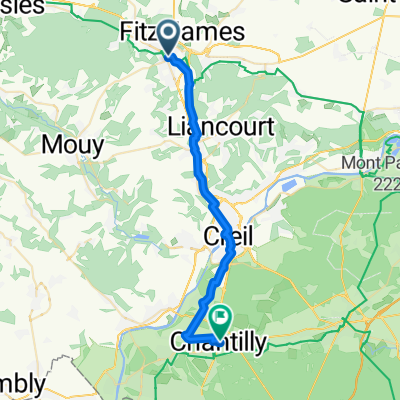
 From Clermont to Chantilly
- Distance
- 28.7 km
- Ascent
- 167 m
- Descent
- 204 m
- Location
- Clermont, Hauts-de-France, France
 Clermont - Senlis
- Distance
- 41.4 km
- Ascent
- 223 m
- Descent
- 227 m
- Location
- Clermont, Hauts-de-France, France
Open it in the app