
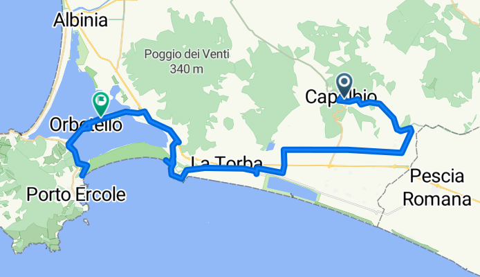
Capalbio-Orbetello-120518
A cycling route starting in Capalbio, Tuscany, Italy.
Overview
About this route
We actually rode over the southern dam (nature reserve) to Orbetello. However, this section cannot be plotted with this program. This part is only partially suitable for road bikes.
- -:--
- Duration
- 50.3 km
- Distance
- 148 m
- Ascent
- 306 m
- Descent
- ---
- Avg. speed
- ---
- Max. altitude
Route quality
Waytypes & surfaces along the route
Waytypes
Road
24.1 km
(48 %)
Quiet road
11.1 km
(22 %)
Surfaces
Paved
28.7 km
(57 %)
Unpaved
0.5 km
(1 %)
Asphalt
26.1 km
(52 %)
Paved (undefined)
2.5 km
(5 %)
Continue with Bikemap
Use, edit, or download this cycling route
You would like to ride Capalbio-Orbetello-120518 or customize it for your own trip? Here is what you can do with this Bikemap route:
Free features
- Save this route as favorite or in collections
- Copy & plan your own version of this route
- Sync your route with Garmin or Wahoo
Premium features
Free trial for 3 days, or one-time payment. More about Bikemap Premium.
- Navigate this route on iOS & Android
- Export a GPX / KML file of this route
- Create your custom printout (try it for free)
- Download this route for offline navigation
Discover more Premium features.
Get Bikemap PremiumFrom our community
Other popular routes starting in Capalbio
 Via Origlio 110, Capalbio Scalo nach Macchiatonda, Capalbio
- Distance
- 3.5 km
- Ascent
- 0 m
- Descent
- 67 m
- Location
- Capalbio, Tuscany, Italy
 Route von Via Origlio 110, Capalbio Scalo
- Distance
- 10.5 km
- Ascent
- 181 m
- Descent
- 58 m
- Location
- Capalbio, Tuscany, Italy
 Capalbio stazione-polverosa-Orbetello scalo
- Distance
- 32.8 km
- Ascent
- 90 m
- Descent
- 87 m
- Location
- Capalbio, Tuscany, Italy
 Capalbio Scalo-Valentano-Capodimonte-Montefiascone-Civita di Bagnoregio
- Distance
- 94.5 km
- Ascent
- 939 m
- Descent
- 534 m
- Location
- Capalbio, Tuscany, Italy
 Capalbio Scalo - Sorano - Sovana
- Distance
- 85.4 km
- Ascent
- 804 m
- Descent
- 521 m
- Location
- Capalbio, Tuscany, Italy
 Capalbio to Roccapesta
- Distance
- 31.4 km
- Ascent
- 351 m
- Descent
- 305 m
- Location
- Capalbio, Tuscany, Italy
 DAY 2 CAPALBIO - SANTA SEVERA
- Distance
- 82.3 km
- Ascent
- 206 m
- Descent
- 220 m
- Location
- Capalbio, Tuscany, Italy
 toscana
- Distance
- 213.3 km
- Ascent
- 1,304 m
- Descent
- 1,265 m
- Location
- Capalbio, Tuscany, Italy
Open it in the app