

Dyje Thaya Herrnbaum-Südmährenkreuz-Mikulov
A cycling route starting in Herrnbaumgarten, Lower Austria, Austria.
Overview
About this route
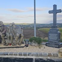
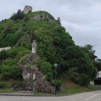
Impressive arrival in Mikulov, from the hill above Herrnbaugarten, Falkenstein, Kellergassen, Südmährenkreuz, as a half-day trip with wine tasting. 2 to 3 hours with tasting, with a visit to the castle ruins also suitable for a full day.
- -:--
- Duration
- 26.3 km
- Distance
- 269 m
- Ascent
- 312 m
- Descent
- ---
- Avg. speed
- ---
- Max. altitude
Route quality
Waytypes & surfaces along the route
Waytypes
Road
7.4 km
(28 %)
Quiet road
5.8 km
(22 %)
Surfaces
Paved
16.6 km
(63 %)
Unpaved
4 km
(15 %)
Asphalt
13.7 km
(52 %)
Paved (undefined)
2.6 km
(10 %)
Continue with Bikemap
Use, edit, or download this cycling route
You would like to ride Dyje Thaya Herrnbaum-Südmährenkreuz-Mikulov or customize it for your own trip? Here is what you can do with this Bikemap route:
Free features
- Save this route as favorite or in collections
- Copy & plan your own version of this route
- Sync your route with Garmin or Wahoo
Premium features
Free trial for 3 days, or one-time payment. More about Bikemap Premium.
- Navigate this route on iOS & Android
- Export a GPX / KML file of this route
- Create your custom printout (try it for free)
- Download this route for offline navigation
Discover more Premium features.
Get Bikemap PremiumFrom our community
Other popular routes starting in Herrnbaumgarten
 Falkenstein
- Distance
- 41.7 km
- Ascent
- 728 m
- Descent
- 728 m
- Location
- Herrnbaumgarten, Lower Austria, Austria
 Weinvierteltour 1090hm, ~ 90km
- Distance
- 89.2 km
- Ascent
- 780 m
- Descent
- 777 m
- Location
- Herrnbaumgarten, Lower Austria, Austria
 Liechtensteinrunde
- Distance
- 56.9 km
- Ascent
- 252 m
- Descent
- 252 m
- Location
- Herrnbaumgarten, Lower Austria, Austria
 Liechtensteinrunde
- Distance
- 84.4 km
- Ascent
- 619 m
- Descent
- 620 m
- Location
- Herrnbaumgarten, Lower Austria, Austria
 Herrnbaumgarten -Mikulov
- Distance
- 69.4 km
- Ascent
- 684 m
- Descent
- 681 m
- Location
- Herrnbaumgarten, Lower Austria, Austria
 Herrnbaumgarten-Tennauwaldrunde
- Distance
- 14.9 km
- Ascent
- 202 m
- Descent
- 208 m
- Location
- Herrnbaumgarten, Lower Austria, Austria
 L22 139, Herrnbaumgarten nach Nexing 17
- Distance
- 33.4 km
- Ascent
- 373 m
- Descent
- 378 m
- Location
- Herrnbaumgarten, Lower Austria, Austria
 Hauptstraße 65, Herrnbaumgarten - Hauptstraße 65, Herrnbaumgarten
- Distance
- 71.8 km
- Ascent
- 677 m
- Descent
- 729 m
- Location
- Herrnbaumgarten, Lower Austria, Austria
Open it in the app