Tracy to Santa Barbara
A cycling route starting in Tracy, California, United States of America.
Overview
About this route
- 44 h 49 min
- Duration
- 676 km
- Distance
- 8,700 m
- Ascent
- 8,728 m
- Descent
- 15.1 km/h
- Avg. speed
- 2,051 m
- Max. altitude
Route quality
Waytypes & surfaces along the route
Waytypes
Quiet road
372.6 km
(55 %)
Access road
96.1 km
(14 %)
Surfaces
Paved
89.8 km
(13 %)
Unpaved
64.8 km
(10 %)
Asphalt
76.4 km
(11 %)
Ground
23.1 km
(3 %)
Continue with Bikemap
Use, edit, or download this cycling route
You would like to ride Tracy to Santa Barbara or customize it for your own trip? Here is what you can do with this Bikemap route:
Free features
- Save this route as favorite or in collections
- Copy & plan your own version of this route
- Split it into stages to create a multi-day tour
- Sync your route with Garmin or Wahoo
Premium features
Free trial for 3 days, or one-time payment. More about Bikemap Premium.
- Navigate this route on iOS & Android
- Export a GPX / KML file of this route
- Create your custom printout (try it for free)
- Download this route for offline navigation
Discover more Premium features.
Get Bikemap PremiumFrom our community
Other popular routes starting in Tracy
- Route to Tracy Hills Park
- Distance
- 10 km
- Ascent
- 61 m
- Descent
- 7 m
- Location
- Tracy, California, United States of America
- Tracy to Santa Barbara
- Distance
- 676 km
- Ascent
- 8,700 m
- Descent
- 8,728 m
- Location
- Tracy, California, United States of America
- Tracy to Livermore
- Distance
- 48.6 km
- Ascent
- 587 m
- Descent
- 468 m
- Location
- Tracy, California, United States of America
- TRACY TO PATTERSON
- Distance
- 47.7 km
- Ascent
- 64 m
- Descent
- 25 m
- Location
- Tracy, California, United States of America
- Tracy to Byron
- Distance
- 26 km
- Ascent
- 136 m
- Descent
- 93 m
- Location
- Tracy, California, United States of America
- Tracy to Gustine
- Distance
- 85.6 km
- Ascent
- 204 m
- Descent
- 162 m
- Location
- Tracy, California, United States of America
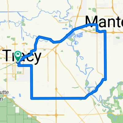
- 12 Phillip Ct, Tracy to 95 Country Ct, Tracy
- Distance
- 9.8 km
- Ascent
- 19 m
- Descent
- 20 m
- Location
- Tracy, California, United States of America
- tracy to stockton
- Distance
- 56.7 km
- Ascent
- 25 m
- Descent
- 62 m
- Location
- Tracy, California, United States of America
Open it in the app