
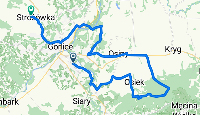
Wieża widokową na Łysuli 551 m n.p.m.
A cycling route starting in Gorlice, Lesser Poland Voivodeship, Poland.
Overview
About this route
- < 1 min
- Duration
- 24.5 km
- Distance
- 392 m
- Ascent
- 378 m
- Descent
- 14,726.4 km/h
- Avg. speed
- 552 m
- Max. altitude

Route photos


Route quality
Waytypes & surfaces along the route
Waytypes
Quiet road
11 km
(45 %)
Track
4.7 km
(19 %)
Surfaces
Paved
14.7 km
(60 %)
Unpaved
0.2 km
(1 %)
Asphalt
14.5 km
(59 %)
Paved (undefined)
0.2 km
(1 %)
Continue with Bikemap
Use, edit, or download this cycling route
You would like to ride Wieża widokową na Łysuli 551 m n.p.m. or customize it for your own trip? Here is what you can do with this Bikemap route:
Free features
- Save this route as favorite or in collections
- Copy & plan your own version of this route
- Sync your route with Garmin or Wahoo
Premium features
Free trial for 3 days, or one-time payment. More about Bikemap Premium.
- Navigate this route on iOS & Android
- Export a GPX / KML file of this route
- Create your custom printout (try it for free)
- Download this route for offline navigation
Discover more Premium features.
Get Bikemap PremiumFrom our community
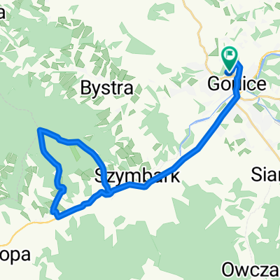
Other popular routes starting in Gorlice
 Cyklokarpaty - Gorlice 2010 (hobby)
- Distance
- 13.6 km
- Ascent
- 245 m
- Descent
- 245 m
- Location
- Gorlice, Lesser Poland Voivodeship, Poland
 Rajd BN'17
- Distance
- 78.1 km
- Ascent
- 729 m
- Descent
- 729 m
- Location
- Gorlice, Lesser Poland Voivodeship, Poland
 Rajd Ostrego Koła - Przehyba
- Distance
- 156.5 km
- Ascent
- 1,818 m
- Descent
- 1,822 m
- Location
- Gorlice, Lesser Poland Voivodeship, Poland
 Cyklokarpaty Gorlice 2011 - Hobby
- Distance
- 17.5 km
- Ascent
- 0 m
- Descent
- 0 m
- Location
- Gorlice, Lesser Poland Voivodeship, Poland
 Stróżówka Maślana Góra do Stróżówka
- Distance
- 30 km
- Ascent
- 762 m
- Descent
- 758 m
- Location
- Gorlice, Lesser Poland Voivodeship, Poland
 #BeskidNiski2000up edycja 2019
- Distance
- 126.4 km
- Ascent
- 1,538 m
- Descent
- 1,537 m
- Location
- Gorlice, Lesser Poland Voivodeship, Poland
 Tour de Pologne Marzeń etap VI Gorlice- Botorowski Wierch
- Distance
- 228.3 km
- Ascent
- 2,096 m
- Descent
- 1,269 m
- Location
- Gorlice, Lesser Poland Voivodeship, Poland
 Maślana Góra/Jelenia Góra
- Distance
- 26.4 km
- Ascent
- 518 m
- Descent
- 518 m
- Location
- Gorlice, Lesser Poland Voivodeship, Poland
Open it in the app