

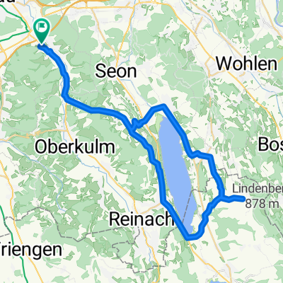
Grä-Schöftland-Rehag-Reinach-Gränichen
A cycling route starting in Gränichen, Canton of Aargau, Switzerland.
Overview
About this route
rolling, well-paved road, mostly with little traffic
- -:--
- Duration
- 44.3 km
- Distance
- 493 m
- Ascent
- 493 m
- Descent
- ---
- Avg. speed
- ---
- Max. altitude
Route quality
Waytypes & surfaces along the route
Waytypes
Road
13.3 km
(30 %)
Quiet road
5.8 km
(13 %)
Surfaces
Paved
17.7 km
(40 %)
Unpaved
0.4 km
(1 %)
Asphalt
15.1 km
(34 %)
Paved (undefined)
2.7 km
(6 %)
Continue with Bikemap
Use, edit, or download this cycling route
You would like to ride Grä-Schöftland-Rehag-Reinach-Gränichen or customize it for your own trip? Here is what you can do with this Bikemap route:
Free features
- Save this route as favorite or in collections
- Copy & plan your own version of this route
- Sync your route with Garmin or Wahoo
Premium features
Free trial for 3 days, or one-time payment. More about Bikemap Premium.
- Navigate this route on iOS & Android
- Export a GPX / KML file of this route
- Create your custom printout (try it for free)
- Download this route for offline navigation
Discover more Premium features.
Get Bikemap PremiumFrom our community
Other popular routes starting in Gränichen
 Gränichen-Leutwil-Mosen-Schongau-Boniswil-Leutwil-Gränichen
- Distance
- 48.5 km
- Ascent
- 682 m
- Descent
- 680 m
- Location
- Gränichen, Canton of Aargau, Switzerland
 Gränichen-Schinznach
- Distance
- 15.9 km
- Ascent
- 75 m
- Descent
- 141 m
- Location
- Gränichen, Canton of Aargau, Switzerland
 Grä-Schöftland-Rehag-Reinach-Gränichen
- Distance
- 44.3 km
- Ascent
- 493 m
- Descent
- 493 m
- Location
- Gränichen, Canton of Aargau, Switzerland
 Gänstelstrasse 29, Gränichen nach Schiffländi 4, Stein am Rhein
- Distance
- 97.4 km
- Ascent
- 1,498 m
- Descent
- 1,516 m
- Location
- Gränichen, Canton of Aargau, Switzerland
 08_RR_2014_Gränichen - Birmensdorf
- Distance
- 42.5 km
- Ascent
- 905 m
- Descent
- 840 m
- Location
- Gränichen, Canton of Aargau, Switzerland
 RR_2014_Gränichen_8
- Distance
- 42.2 km
- Ascent
- 904 m
- Descent
- 843 m
- Location
- Gränichen, Canton of Aargau, Switzerland
 Gränichen-Schinznach
- Distance
- 15.9 km
- Ascent
- 57 m
- Descent
- 121 m
- Location
- Gränichen, Canton of Aargau, Switzerland
 Talbachstrasse 23, Gränichen to Talbachstrasse 23, Gränichen
- Distance
- 97.3 km
- Ascent
- 2,493 m
- Descent
- 2,506 m
- Location
- Gränichen, Canton of Aargau, Switzerland
Open it in the app