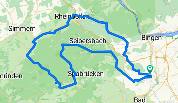
Soonwaldtour
A cycling route starting in Langenlonsheim, Rhineland-Palatinate, Germany.
Overview
About this route
Lalo-Lauschhütte-Kandrich-Ellerspring-(Malepartus eine Weizenbier bleifrei)-Schanzerkopf-und dann ab heim
- -:--
- Duration
- 93.6 km
- Distance
- 1,119 m
- Ascent
- 1,119 m
- Descent
- ---
- Avg. speed
- ---
- Avg. speed
Route quality
Waytypes & surfaces along the route
Waytypes
Busy road
35.6 km
(38 %)
Track
26.5 km
(28 %)
Surfaces
Paved
58.3 km
(62 %)
Unpaved
13.1 km
(14 %)
Asphalt
53 km
(57 %)
Gravel
11.1 km
(12 %)
Continue with Bikemap
Use, edit, or download this cycling route
You would like to ride Soonwaldtour or customize it for your own trip? Here is what you can do with this Bikemap route:
Free features
- Save this route as favorite or in collections
- Copy & plan your own version of this route
- Sync your route with Garmin or Wahoo
Premium features
Free trial for 3 days, or one-time payment. More about Bikemap Premium.
- Navigate this route on iOS & Android
- Export a GPX / KML file of this route
- Create your custom printout (try it for free)
- Download this route for offline navigation
Discover more Premium features.
Get Bikemap PremiumFrom our community
Other popular routes starting in Langenlonsheim
- Eröffnung 2016
- Distance
- 67 km
- Ascent
- 697 m
- Descent
- 698 m
- Location
- Langenlonsheim, Rhineland-Palatinate, Germany
- Hunsrück1
- Distance
- 86.1 km
- Ascent
- 1,167 m
- Descent
- 1,058 m
- Location
- Langenlonsheim, Rhineland-Palatinate, Germany
- Lalo - Niederheimbach(Rhein) - Jägerhaus(BIN-Wald) - Stromberg - Lalo
- Distance
- 54.2 km
- Ascent
- 697 m
- Descent
- 696 m
- Location
- Langenlonsheim, Rhineland-Palatinate, Germany
- Lalo - Münchberg - Gräfenbachtal - Lalo
- Distance
- 48.1 km
- Ascent
- 764 m
- Descent
- 766 m
- Location
- Langenlonsheim, Rhineland-Palatinate, Germany
- Lalo-NiederOlm-Lalo
- Distance
- 65.5 km
- Ascent
- 482 m
- Descent
- 484 m
- Location
- Langenlonsheim, Rhineland-Palatinate, Germany
- Lauschhütte 2014
- Distance
- 52.6 km
- Ascent
- 613 m
- Descent
- 611 m
- Location
- Langenlonsheim, Rhineland-Palatinate, Germany
- Auf und nieder
- Distance
- 104 km
- Ascent
- 1,896 m
- Descent
- 1,837 m
- Location
- Langenlonsheim, Rhineland-Palatinate, Germany
- Sykwalk
- Distance
- 94.8 km
- Ascent
- 732 m
- Descent
- 735 m
- Location
- Langenlonsheim, Rhineland-Palatinate, Germany
Open it in the app