

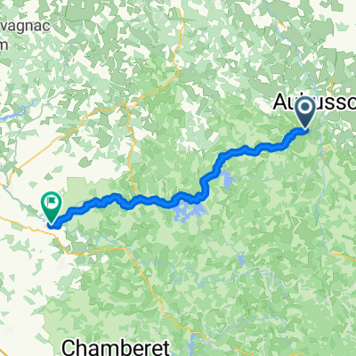
2009 Euro Tour -- Ride Day 4 —24 June 2009—23200 Aubusson to 63390 Saint Gervais d'Auvergne
A cycling route starting in Aubusson, Nouvelle-Aquitaine, France.
Overview
About this route
Beautiful low traffic country roads with plenty of climbing and descents. During the ride, we passed from Creuse into Puy de Dôme.Background:My wife and I have been doing self-supported tours in Western Europe (a majority in France) since 1993. This series of rides covers our 2009 4.5 month route through parts of France, Germany, Austria, Switzerland, and then back to France. Our beginning and ending point is near Chadurie (south of Angouleme) where our friends have a farm with Gites and Chambres d'Hotes.We rode our Dawes touring bicycles purchased in 1993 heavily loaded with 700Cx32 tires. All of our riding was on paved roads, mostly with very little traffic. Pretty much the only unpaved sections were some bicycle paths in Germany and Austria. Sadly, that wasn't so great as Helen fell a number of times on the unpaved paths. Fortunately, though, no serious injury.If any questions, feel free to email me at jeffkadet@netdiving.comJeff
- -:--
- Duration
- 64.9 km
- Distance
- 921 m
- Ascent
- 638 m
- Descent
- ---
- Avg. speed
- ---
- Max. altitude

Route quality
Waytypes & surfaces along the route
Waytypes
Road
30.5 km
(47 %)
Quiet road
1.9 km
(3 %)
Undefined
32.4 km
(50 %)
Surfaces
Paved
22.7 km
(35 %)
Asphalt
22.7 km
(35 %)
Undefined
42.2 km
(65 %)
Continue with Bikemap
Use, edit, or download this cycling route
You would like to ride 2009 Euro Tour -- Ride Day 4 —24 June 2009—23200 Aubusson to 63390 Saint Gervais d'Auvergne or customize it for your own trip? Here is what you can do with this Bikemap route:
Free features
- Save this route as favorite or in collections
- Copy & plan your own version of this route
- Sync your route with Garmin or Wahoo
Premium features
Free trial for 3 days, or one-time payment. More about Bikemap Premium.
- Navigate this route on iOS & Android
- Export a GPX / KML file of this route
- Create your custom printout (try it for free)
- Download this route for offline navigation
Discover more Premium features.
Get Bikemap PremiumFrom our community
Other popular routes starting in Aubusson
 Aubusson to Evaux-les-Bains - Part on V87
- Distance
- 48.2 km
- Ascent
- 587 m
- Descent
- 692 m
- Location
- Aubusson, Nouvelle-Aquitaine, France
 etape 11 : aubusson - confolant
- Distance
- 59 km
- Ascent
- 945 m
- Descent
- 850 m
- Location
- Aubusson, Nouvelle-Aquitaine, France
 Creuse 4
- Distance
- 49.3 km
- Ascent
- 440 m
- Descent
- 553 m
- Location
- Aubusson, Nouvelle-Aquitaine, France
 Aubusson - Neuvic 80 km
- Distance
- 79.4 km
- Ascent
- 858 m
- Descent
- 671 m
- Location
- Aubusson, Nouvelle-Aquitaine, France
 Aubusson - Mont Dore
- Distance
- 202 km
- Ascent
- 3,600 m
- Descent
- 2,871 m
- Location
- Aubusson, Nouvelle-Aquitaine, France
 Aubusson - Neuvic-Entier
- Distance
- 63.5 km
- Ascent
- 1,092 m
- Descent
- 1,279 m
- Location
- Aubusson, Nouvelle-Aquitaine, France
 2009 Euro Tour -- Ride Day 4 —24 June 2009—23200 Aubusson to 63390 Saint Gervais d'Auvergne
- Distance
- 64.9 km
- Ascent
- 921 m
- Descent
- 638 m
- Location
- Aubusson, Nouvelle-Aquitaine, France
 Tour du Limousin 7 (Aubusson-Ussel)
- Distance
- 70 km
- Ascent
- 893 m
- Descent
- 686 m
- Location
- Aubusson, Nouvelle-Aquitaine, France
Open it in the app