

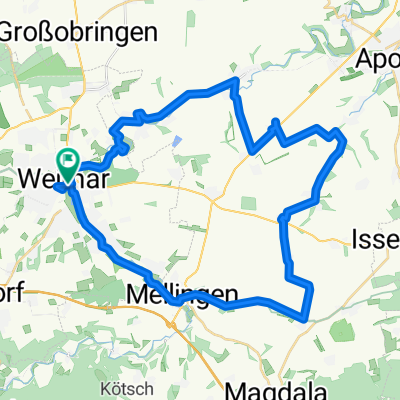
Rundtour um Weimar
A cycling route starting in Weimar, Thuringia, Germany.
Overview
About this route
A relaxed tour initially heading towards Jena along the Ilmtalradweg, then turning towards Lehnstedt in the direction of Apolda, to get back on the Ilmtalradweg towards Weimar. Route tracked via GPS.
- -:--
- Duration
- 41.2 km
- Distance
- 241 m
- Ascent
- 249 m
- Descent
- ---
- Avg. speed
- 334 m
- Max. altitude

Route quality
Waytypes & surfaces along the route
Waytypes
Track
14.8 km
(36 %)
Road
12.4 km
(30 %)
Surfaces
Paved
31.3 km
(76 %)
Unpaved
6.2 km
(15 %)
Asphalt
27.6 km
(67 %)
Concrete
3.7 km
(9 %)
Continue with Bikemap
Use, edit, or download this cycling route
You would like to ride Rundtour um Weimar or customize it for your own trip? Here is what you can do with this Bikemap route:
Free features
- Save this route as favorite or in collections
- Copy & plan your own version of this route
- Sync your route with Garmin or Wahoo
Premium features
Free trial for 3 days, or one-time payment. More about Bikemap Premium.
- Navigate this route on iOS & Android
- Export a GPX / KML file of this route
- Create your custom printout (try it for free)
- Download this route for offline navigation
Discover more Premium features.
Get Bikemap PremiumFrom our community
Other popular routes starting in Weimar
 Friedensradfahrt 2009 Paris - Moskau 15. Etappe Weimar - Bad Sulza am 20. Juli 2009
- Distance
- 29.1 km
- Ascent
- 192 m
- Descent
- 260 m
- Location
- Weimar, Thuringia, Germany
 Von Weimar bis Leipzig
- Distance
- 110.8 km
- Ascent
- 630 m
- Descent
- 744 m
- Location
- Weimar, Thuringia, Germany
 Leibnizallee 1A nach Corona-Schröter-Weg
- Distance
- 7.3 km
- Ascent
- 81 m
- Descent
- 89 m
- Location
- Weimar, Thuringia, Germany
 Trainingsrunde 13/14
- Distance
- 24.8 km
- Ascent
- 253 m
- Descent
- 253 m
- Location
- Weimar, Thuringia, Germany
 Rundtour um Weimar
- Distance
- 41.2 km
- Ascent
- 241 m
- Descent
- 249 m
- Location
- Weimar, Thuringia, Germany
 100km Trainingsrunde in Weimars Süden
- Distance
- 99.3 km
- Ascent
- 962 m
- Descent
- 901 m
- Location
- Weimar, Thuringia, Germany
 Himmelfahrtausfahrt (Weimarer Löwen) 2012-05-17
- Distance
- 77.7 km
- Ascent
- 435 m
- Descent
- 435 m
- Location
- Weimar, Thuringia, Germany
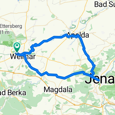 Pętla Weimar-Apolda-Jena-Weimar
- Distance
- 59.2 km
- Ascent
- 570 m
- Descent
- 575 m
- Location
- Weimar, Thuringia, Germany
Open it in the app