2010 - Přejezd slovenských hor
A cycling route starting in Vsetín, Zlín, Czechia.
Overview
About this route
-
-
-
-
- 2010
-
-
-
Vsetín - Horní Lideč - Lysá pod Makytou - Púchov - Považská Bystrica - Rajec - Fačkov - Nitrianské Pravno - Turčianske Teplice - Harmanec - Donovaly - Liptovská Lúžna - Liptovský Mikuláš - Liptovská Teplička - SNV
- -:--
- Duration
- 351.3 km
- Distance
- 2,478 m
- Ascent
- 2,359 m
- Descent
- ---
- Avg. speed
- ---
- Avg. speed
Route quality
Waytypes & surfaces along the route
Waytypes
Busy road
175.6 km
(50 %)
Road
79 km
(22 %)
Surfaces
Paved
151.5 km
(43 %)
Unpaved
27.9 km
(8 %)
Asphalt
143 km
(41 %)
Gravel
14.6 km
(4 %)
Route highlights
Points of interest along the route
Accommodation after 26.8 km
1. nocleh, 29 km
Accommodation after 101.1 km
2. nocleh, 77 km, celkem 106 km
Accommodation after 199.3 km
3. nocleh, 98 km, celkem 204 km
Accommodation after 274.2 km
4. nocleh, 74 km, celkem 278 km
Continue with Bikemap
Use, edit, or download this cycling route
You would like to ride 2010 - Přejezd slovenských hor or customize it for your own trip? Here is what you can do with this Bikemap route:
Free features
- Save this route as favorite or in collections
- Copy & plan your own version of this route
- Sync your route with Garmin or Wahoo
Premium features
Free trial for 3 days, or one-time payment. More about Bikemap Premium.
- Navigate this route on iOS & Android
- Export a GPX / KML file of this route
- Create your custom printout (try it for free)
- Download this route for offline navigation
Discover more Premium features.
Get Bikemap PremiumFrom our community
Other popular routes starting in Vsetín
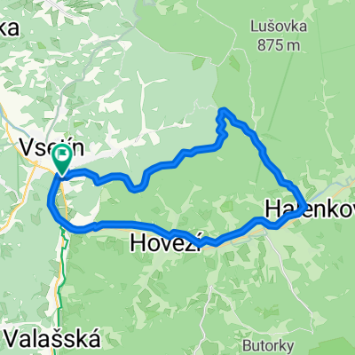
- Ohrada-Dinotice-Nad Červenkou- U Krošenků-Trojúhelník-Ohrada
- Distance
- 29.9 km
- Ascent
- 414 m
- Descent
- 411 m
- Location
- Vsetín, Zlín, Czechia
- 10.Vsetin-Spytihnev
- Distance
- 55.1 km
- Ascent
- 222 m
- Descent
- 387 m
- Location
- Vsetín, Zlín, Czechia
- Vsetím-Pustevny-Solan-Vsetin
- Distance
- 110.7 km
- Ascent
- 1,112 m
- Descent
- 1,112 m
- Location
- Vsetín, Zlín, Czechia
- 2010 - Přejezd slovenských hor
- Distance
- 351.3 km
- Ascent
- 2,478 m
- Descent
- 2,359 m
- Location
- Vsetín, Zlín, Czechia
- SK - 1. etapa - RACAS
- Distance
- 263 km
- Ascent
- 5,939 m
- Descent
- 5,578 m
- Location
- Vsetín, Zlín, Czechia
- Vsetín - Velké Karlovice - Čarták - Vsacký Cáb - Bystřička
- Distance
- 64.3 km
- Ascent
- 691 m
- Descent
- 728 m
- Location
- Vsetín, Zlín, Czechia
- MORAVA-1.den-15.7.13
- Distance
- 12.7 km
- Ascent
- 120 m
- Descent
- 130 m
- Location
- Vsetín, Zlín, Czechia
- Trasa s Danem
- Distance
- 34.3 km
- Ascent
- 955 m
- Descent
- 961 m
- Location
- Vsetín, Zlín, Czechia
Open it in the app