
"Auf den Schaumberg"
A cycling route starting in Schmelz, Saarland, Germany.
Overview
About this route
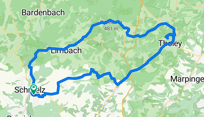
Von Schmelz zum Hausberg des Saarlandes, meine Lieblingsroute, am Schmelzer Brauhaus vorbei erst zum Friesenhof, dann von Gresaubach aus hinauf nach Höchsten, nach Thalexweiler beginnt dann am Ausgang von Sotzweiler der Aufstieg zum Schaumberg, das Finale des Berges nach der Durchfahrt von Tholey dann schmerzhaft und sogar mit 50m Kopfsteinpflaster zum Schluss, dafür ein schöne Aussicht vom Parkplatz unterhalb des Gipfels, ein schönes Plätzchen ist das Gipfelplateau mit dem Schumbergturm. Zurück gehts dann über Theley und Hasborn, der letzte Anstieg des Tages dann der Sattelkopf, nach Schmelz rollt es dann aus über Überroth, Lindscheid, Dorf, Limbach und Schattertriesch
- -:--
- Duration
- 42.6 km
- Distance
- 784 m
- Ascent
- 780 m
- Descent
- ---
- Avg. speed
- 570 m
- Max. altitude
Route quality
Waytypes & surfaces along the route
Waytypes
Busy road
12.3 km
(29 %)
Quiet road
10.8 km
(25 %)
Surfaces
Paved
27.2 km
(64 %)
Unpaved
0.4 km
(1 %)
Asphalt
23.3 km
(55 %)
Paved (undefined)
3.9 km
(9 %)
Continue with Bikemap
Use, edit, or download this cycling route
You would like to ride "Auf den Schaumberg" or customize it for your own trip? Here is what you can do with this Bikemap route:
Free features
- Save this route as favorite or in collections
- Copy & plan your own version of this route
- Sync your route with Garmin or Wahoo
Premium features
Free trial for 3 days, or one-time payment. More about Bikemap Premium.
- Navigate this route on iOS & Android
- Export a GPX / KML file of this route
- Create your custom printout (try it for free)
- Download this route for offline navigation
Discover more Premium features.
Get Bikemap PremiumFrom our community
Other popular routes starting in Schmelz
 Wendelinus-Fahrt 2013 - RTF des RSC Haustadter Tal Reimsbach e.V. - 118 km Strecke
- Distance
- 114.7 km
- Ascent
- 1,313 m
- Descent
- 1,246 m
- Location
- Schmelz, Saarland, Germany
 Hochwaldtrail
- Distance
- 69.7 km
- Ascent
- 767 m
- Descent
- 767 m
- Location
- Schmelz, Saarland, Germany
 Mövenmarathon 2008 - Marathon des RV Möve Schmelz e.V. - 202 km Strecke
- Distance
- 198.6 km
- Ascent
- 2,021 m
- Descent
- 1,834 m
- Location
- Schmelz, Saarland, Germany
 Rund um Schmelz/ Hüttersdorf
- Distance
- 17.6 km
- Ascent
- 188 m
- Descent
- 190 m
- Location
- Schmelz, Saarland, Germany
 Gipfel-Trail
- Distance
- 33.9 km
- Ascent
- 509 m
- Descent
- 509 m
- Location
- Schmelz, Saarland, Germany
 Limbach Hoxfels
- Distance
- 11.7 km
- Ascent
- 282 m
- Descent
- 281 m
- Location
- Schmelz, Saarland, Germany
 "Auf den Schaumberg"
- Distance
- 42.6 km
- Ascent
- 784 m
- Descent
- 780 m
- Location
- Schmelz, Saarland, Germany
 Schmelzer Runde
- Distance
- 14.9 km
- Ascent
- 209 m
- Descent
- 210 m
- Location
- Schmelz, Saarland, Germany
Open it in the app