

Über die Berge von Schlücht- und Steinatal.
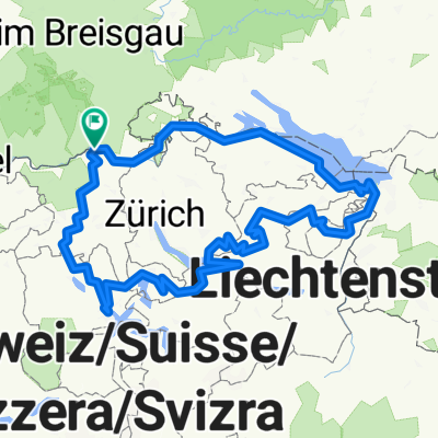
A cycling route starting in Koblenz, Canton of Aargau, Switzerland.
Overview
About this route
To Eggingen, the bike must be quickly carried through a construction site.
- -:--
- Duration
- 105.2 km
- Distance
- 1,923 m
- Ascent
- 1,930 m
- Descent
- ---
- Avg. speed
- ---
- Max. altitude

Route quality
Waytypes & surfaces along the route
Waytypes
Road
31.6 km
(30 %)
Quiet road
26.3 km
(25 %)
Surfaces
Paved
55.8 km
(53 %)
Unpaved
2.1 km
(2 %)
Asphalt
52.6 km
(50 %)
Paved (undefined)
3.2 km
(3 %)
Continue with Bikemap
Use, edit, or download this cycling route
You would like to ride Über die Berge von Schlücht- und Steinatal. or customize it for your own trip? Here is what you can do with this Bikemap route:
Free features
- Save this route as favorite or in collections
- Copy & plan your own version of this route
- Split it into stages to create a multi-day tour
- Sync your route with Garmin or Wahoo
Premium features
Free trial for 3 days, or one-time payment. More about Bikemap Premium.
- Navigate this route on iOS & Android
- Export a GPX / KML file of this route
- Create your custom printout (try it for free)
- Download this route for offline navigation
Discover more Premium features.
Get Bikemap PremiumFrom our community
Other popular routes starting in Koblenz
 teil4 mit herzenroute 580km
- Distance
- 576.4 km
- Ascent
- 9,803 m
- Descent
- 9,803 m
- Location
- Koblenz, Canton of Aargau, Switzerland
 Koblenz nach Trasadingen
- Distance
- 22.1 km
- Ascent
- 103 m
- Descent
- 12 m
- Location
- Koblenz, Canton of Aargau, Switzerland
 Route de l'Aar
- Distance
- 301.3 km
- Ascent
- 585 m
- Descent
- 280 m
- Location
- Koblenz, Canton of Aargau, Switzerland
 Bodenseeumfahrung
- Distance
- 312.7 km
- Ascent
- 538 m
- Descent
- 538 m
- Location
- Koblenz, Canton of Aargau, Switzerland
 virée en foret noire/danube Constance etape 1 walshut lac de Titisee
- Distance
- 51 km
- Ascent
- 801 m
- Descent
- 263 m
- Location
- Koblenz, Canton of Aargau, Switzerland
 Rhein 2019 2. Etappe
- Distance
- 59.9 km
- Ascent
- 199 m
- Descent
- 262 m
- Location
- Koblenz, Canton of Aargau, Switzerland
 Rhein - Wannenbwerg - Wutach
- Distance
- 42.9 km
- Ascent
- 606 m
- Descent
- 603 m
- Location
- Koblenz, Canton of Aargau, Switzerland
 Waldshut - Lörrach
- Distance
- 68.4 km
- Ascent
- 194 m
- Descent
- 166 m
- Location
- Koblenz, Canton of Aargau, Switzerland
Open it in the app