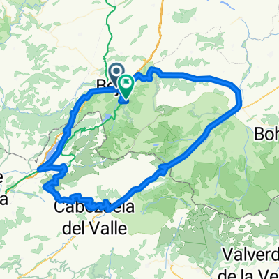
Béjar - Llano Alto - Pantano Navamuño - Candelario - Los Pinos - Béjar
- 18.6 km
- 470 m
- 467 m
- Béjar, Castille and León, Spain
A cycling route starting in Béjar, Castille and León, Spain.
Overview
Route with a large portion on road but little traffic. Water is available throughout the route (no need to carry a bottle), even in summer. Recommended at any time of year, but be careful in winter due to cold and snow.
We start from the bus station heading towards Salamanca via the old N-630. Just after crossing the bridge, we turn right to enter an area called Los Pinos. A few days ago, a Spanish national mountain bike championship event was held here. Los Pinos is an area with many paths and trails. We will only ascend to the Candelario - Navacarros road via the calleja de la Víbora (towards Garganta del Oso). Once on the road, we head towards Candelario, a lovely mountain village that merits a short visit for its steep and pretty streets. We continue along the road towards La Garganta. This stretch of road is very beautiful and has little car traffic. After passing the boundary with Cáceres, we continue slightly and see a path to the left, the Cancho de la Muela loop. From here there are impressive views of the Ambroz Valley. After finishing the Muela loop, we return by road to the Navamuño dam, which we cross, then turn right to reach Llano Alto, where the hostel is situated. The descent through the Castañar can be done by trails (as in this case) or by road. Don’t hesitate to stop to see the oldest bullring in Spain.
created this 13 years ago
Continue with Bikemap
You would like to ride Béjar - Los Pinos - Candelario - Cancho la Muela - Llano Alto - Béjar or customize it for your own trip? Here is what you can do with this Bikemap route:
Free trial for 3 days, or one-time payment. More about Bikemap Premium.
Discover more Premium features.
Get Bikemap PremiumFrom our community
Open it in the app