

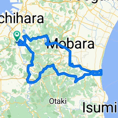
Bo-So Cencury Ride
A cycling route starting in Ichihara, Chiba, Japan.
Overview
About this route
There are many tunnels on the route.
Should bring a headlight.
- -:--
- Duration
- 159.6 km
- Distance
- 856 m
- Ascent
- 856 m
- Descent
- ---
- Avg. speed
- ---
- Max. altitude
Continue with Bikemap
Use, edit, or download this cycling route
You would like to ride Bo-So Cencury Ride or customize it for your own trip? Here is what you can do with this Bikemap route:
Free features
- Save this route as favorite or in collections
- Copy & plan your own version of this route
- Split it into stages to create a multi-day tour
- Sync your route with Garmin or Wahoo
Premium features
Free trial for 3 days, or one-time payment. More about Bikemap Premium.
- Navigate this route on iOS & Android
- Export a GPX / KML file of this route
- Create your custom printout (try it for free)
- Download this route for offline navigation
Discover more Premium features.
Get Bikemap PremiumFrom our community
Other popular routes starting in Ichihara
 Bo-So Cencury Ride
- Distance
- 159.6 km
- Ascent
- 856 m
- Descent
- 856 m
- Location
- Ichihara, Chiba, Japan
 BR-CCT-Ichihara-Ichinomiya-Circuit
- Distance
- 96 km
- Ascent
- 431 m
- Descent
- 429 m
- Location
- Ichihara, Chiba, Japan
 Chiba
Chiba- Distance
- 30.7 km
- Ascent
- 362 m
- Descent
- 350 m
- Location
- Ichihara, Chiba, Japan
 高津湖外裏道②
- Distance
- 23 km
- Ascent
- 260 m
- Descent
- 198 m
- Location
- Ichihara, Chiba, Japan
 市津湖裏道①
- Distance
- 7.9 km
- Ascent
- 111 m
- Descent
- 37 m
- Location
- Ichihara, Chiba, Japan
 Odappe, Ichihara to 337, Yamanogo, Nagara, Chosei-Gun
- Distance
- 9.2 km
- Ascent
- 510 m
- Descent
- 436 m
- Location
- Ichihara, Chiba, Japan
 NATURE-MURATAGAWA
- Distance
- 15.5 km
- Ascent
- 160 m
- Descent
- 105 m
- Location
- Ichihara, Chiba, Japan
 Yawata, Ichihara a 1316-17, Kami, Ageo
- Distance
- 91.6 km
- Ascent
- 342 m
- Descent
- 326 m
- Location
- Ichihara, Chiba, Japan
Open it in the app