

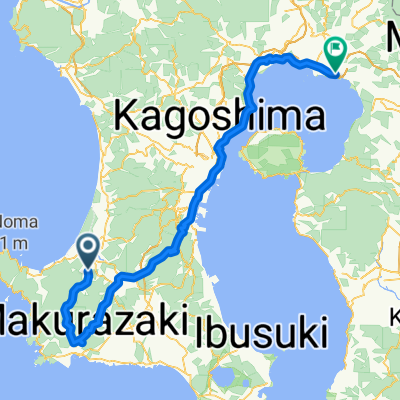
Day 539
A cycling route starting in Kaseda-shirakame, Kagoshima, Japan.
Overview
About this route
- -:--
- Duration
- 40.3 km
- Distance
- 260 m
- Ascent
- 411 m
- Descent
- ---
- Avg. speed
- 161 m
- Max. altitude

Continue with Bikemap
Use, edit, or download this cycling route
You would like to ride Day 539 or customize it for your own trip? Here is what you can do with this Bikemap route:
Free features
- Save this route as favorite or in collections
- Copy & plan your own version of this route
- Sync your route with Garmin or Wahoo
Premium features
Free trial for 3 days, or one-time payment. More about Bikemap Premium.
- Navigate this route on iOS & Android
- Export a GPX / KML file of this route
- Create your custom printout (try it for free)
- Download this route for offline navigation
Discover more Premium features.
Get Bikemap PremiumFrom our community
Other popular routes starting in Kaseda-shirakame
 一般県道加世田日吉自転車道線(吹上浜砂丘自転車道)
- Distance
- 23 km
- Ascent
- 145 m
- Descent
- 138 m
- Location
- Kaseda-shirakame, Kagoshima, Japan
 鹿児島一周「かごイチ」コース
- Distance
- 242.9 km
- Ascent
- 3,370 m
- Descent
- 3,371 m
- Location
- Kaseda-shirakame, Kagoshima, Japan
 fukiageRD-bounotsu
- Distance
- 26 km
- Ascent
- 352 m
- Descent
- 349 m
- Location
- Kaseda-shirakame, Kagoshima, Japan
 Kaseda-shirakame - Kokubu-matsuki
- Distance
- 107.9 km
- Ascent
- 234 m
- Descent
- 237 m
- Location
- Kaseda-shirakame, Kagoshima, Japan
 fukiageRD-bounotsu
- Distance
- 25.7 km
- Ascent
- 361 m
- Descent
- 357 m
- Location
- Kaseda-shirakame, Kagoshima, Japan
 きんぽう田の神さぁ巡りコース
- Distance
- 18.4 km
- Ascent
- 85 m
- Descent
- 85 m
- Location
- Kaseda-shirakame, Kagoshima, Japan
 Ibusuki - Chiran
- Distance
- 36.3 km
- Ascent
- 418 m
- Descent
- 580 m
- Location
- Kaseda-shirakame, Kagoshima, Japan
 歴史散走・寄り道スイーツコース
- Distance
- 15.6 km
- Ascent
- 48 m
- Descent
- 47 m
- Location
- Kaseda-shirakame, Kagoshima, Japan
Open it in the app