

Ruta del Desierto - Santa Fe
A cycling route starting in Huércal de Almería, Andalusia, Spain.
Overview
About this route
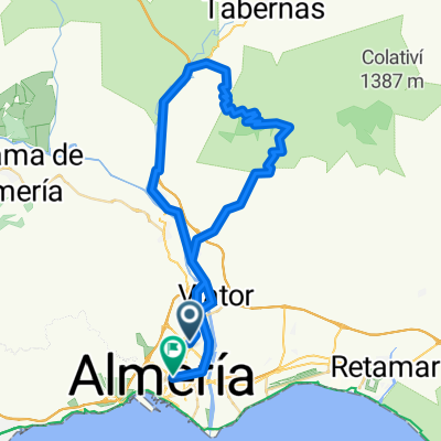
Almería - Cruce de Tabernas - Santa Fe
- -:--
- Duration
- 63.7 km
- Distance
- 588 m
- Ascent
- 610 m
- Descent
- ---
- Avg. speed
- ---
- Max. altitude
Continue with Bikemap
Use, edit, or download this cycling route
You would like to ride Ruta del Desierto - Santa Fe or customize it for your own trip? Here is what you can do with this Bikemap route:
Free features
- Save this route as favorite or in collections
- Copy & plan your own version of this route
- Sync your route with Garmin or Wahoo
Premium features
Free trial for 3 days, or one-time payment. More about Bikemap Premium.
- Navigate this route on iOS & Android
- Export a GPX / KML file of this route
- Create your custom printout (try it for free)
- Download this route for offline navigation
Discover more Premium features.
Get Bikemap PremiumFrom our community
Other popular routes starting in Huércal de Almería
 Ruta del Desierto - Santa Fe
- Distance
- 63.7 km
- Ascent
- 588 m
- Descent
- 610 m
- Location
- Huércal de Almería, Andalusia, Spain
 ALMERIA-AGUADULCE ENDURO
- Distance
- 25.1 km
- Ascent
- 841 m
- Descent
- 834 m
- Location
- Huércal de Almería, Andalusia, Spain
 Piedras Redondas-Quemadero-El Potro
- Distance
- 31.4 km
- Ascent
- 665 m
- Descent
- 660 m
- Location
- Huércal de Almería, Andalusia, Spain
 Almeria - Antenas Sierra Alhamilla - Los Baños
- Distance
- 61.7 km
- Ascent
- 1,221 m
- Descent
- 1,296 m
- Location
- Huércal de Almería, Andalusia, Spain
 Chilindro
- Distance
- 14.9 km
- Ascent
- 825 m
- Descent
- 547 m
- Location
- Huércal de Almería, Andalusia, Spain
 Sierra Alhamilla 20090221
- Distance
- 105 km
- Ascent
- 1,579 m
- Descent
- 1,581 m
- Location
- Huércal de Almería, Andalusia, Spain
 Huercal - Baños de Sierra Alhamilla
- Distance
- 25.8 km
- Ascent
- 442 m
- Descent
- 442 m
- Location
- Huércal de Almería, Andalusia, Spain
 AGAVE-Cerro de la Sima-Cerro de la Víbora-Cerro Gallado-El Pocico-Sendero Tizón-Sendero de María-AGAVE
- Distance
- 11.9 km
- Ascent
- 607 m
- Descent
- 739 m
- Location
- Huércal de Almería, Andalusia, Spain
Open it in the app