

Paris 2012
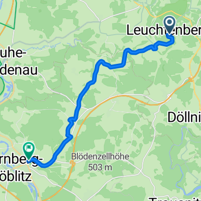
A cycling route starting in Leuchtenberg, Bavaria, Germany.
Overview
About this route
Čím více zde napíšete informací, tím více bude užitečnější pro ostatním uživatele.<br /><br />* Průběh trasy.<br />* Co je zvláštní na této trase?<br />* Proč doporučit tuto trasu?<br />* Co se Vám zde nejvíce líbilo?<br />* Atd.
- -:--
- Duration
- 1,005 km
- Distance
- 916 m
- Ascent
- 1,434 m
- Descent
- ---
- Avg. speed
- ---
- Max. altitude
Continue with Bikemap
Use, edit, or download this cycling route
You would like to ride Paris 2012 or customize it for your own trip? Here is what you can do with this Bikemap route:
Free features
- Save this route as favorite or in collections
- Copy & plan your own version of this route
- Split it into stages to create a multi-day tour
- Sync your route with Garmin or Wahoo
Premium features
Free trial for 3 days, or one-time payment. More about Bikemap Premium.
- Navigate this route on iOS & Android
- Export a GPX / KML file of this route
- Create your custom printout (try it for free)
- Download this route for offline navigation
Discover more Premium features.
Get Bikemap PremiumFrom our community
Other popular routes starting in Leuchtenberg
 Am Ringelbrunnen nach Marktplatz
- Distance
- 12.9 km
- Ascent
- 220 m
- Descent
- 346 m
- Location
- Leuchtenberg, Bavaria, Germany
 Glaubenwies
- Distance
- 6.6 km
- Ascent
- 228 m
- Descent
- 228 m
- Location
- Leuchtenberg, Bavaria, Germany
 Am Kellerhals 5, Leuchtenberg nach Hindenburgallee 3, Munster
- Distance
- 554.9 km
- Ascent
- 4,860 m
- Descent
- 5,271 m
- Location
- Leuchtenberg, Bavaria, Germany
 Paris July 2016
- Distance
- 958.9 km
- Ascent
- 852 m
- Descent
- 1,338 m
- Location
- Leuchtenberg, Bavaria, Germany
 Cesta nahrana z hodinek
- Distance
- 2,983 km
- Ascent
- 8,698 m
- Descent
- 8,826 m
- Location
- Leuchtenberg, Bavaria, Germany
 Leuchtenberger_Rundwanderweg
- Distance
- 11.9 km
- Ascent
- 265 m
- Descent
- 268 m
- Location
- Leuchtenberg, Bavaria, Germany
 Leuchtenberg Wittschau
- Distance
- 5.9 km
- Ascent
- 121 m
- Descent
- 75 m
- Location
- Leuchtenberg, Bavaria, Germany
 Am Ringelbrunnen 1, Leuchtenberg nach Sedanstraße 1, Weiden in der Oberpfalz
- Distance
- 23.9 km
- Ascent
- 219 m
- Descent
- 367 m
- Location
- Leuchtenberg, Bavaria, Germany
Open it in the app