

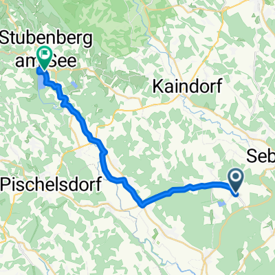
A2 Natur-Erlebnisweg
A cycling route starting in Hartl, Styria, Austria.
Overview
About this route
- 20 min
- Duration
- 4.9 km
- Distance
- 68 m
- Ascent
- 68 m
- Descent
- 14.8 km/h
- Avg. speed
- 445 m
- Max. altitude
Route quality
Waytypes & surfaces along the route
Waytypes
Track
3.1 km
(62 %)
Quiet road
0.7 km
(15 %)
Surfaces
Paved
0.4 km
(9 %)
Unpaved
2.6 km
(53 %)
Gravel
1.3 km
(26 %)
Ground
0.8 km
(17 %)
Continue with Bikemap
Use, edit, or download this cycling route
You would like to ride A2 Natur-Erlebnisweg or customize it for your own trip? Here is what you can do with this Bikemap route:
Free features
- Save this route as favorite or in collections
- Copy & plan your own version of this route
- Sync your route with Garmin or Wahoo
Premium features
Free trial for 3 days, or one-time payment. More about Bikemap Premium.
- Navigate this route on iOS & Android
- Export a GPX / KML file of this route
- Create your custom printout (try it for free)
- Download this route for offline navigation
Discover more Premium features.
Get Bikemap PremiumFrom our community
Other popular routes starting in Hartl
 Auffen .22, Neusiedl nach Campingweg 316, Bad Waltersdorf
- Distance
- 8.4 km
- Ascent
- 36 m
- Descent
- 187 m
- Location
- Hartl, Styria, Austria
 A4 Hohenbrugger-Weg
- Distance
- 11.3 km
- Ascent
- 128 m
- Descent
- 128 m
- Location
- Hartl, Styria, Austria
 Kopfing 73, Kaindorf nach Kleinsteinbach 100, Kleinsteinbach
- Distance
- 14.8 km
- Ascent
- 64 m
- Descent
- 196 m
- Location
- Hartl, Styria, Austria
 Großhart 179, Hartl nach Roseggergasse 3, Hartberg
- Distance
- 20.9 km
- Ascent
- 250 m
- Descent
- 313 m
- Location
- Hartl, Styria, Austria
 Großhart 109, Großhart nach Buchberg, Stubenberg
- Distance
- 20.6 km
- Ascent
- 466 m
- Descent
- 492 m
- Location
- Hartl, Styria, Austria
 A2 Natur-Erlebnisweg
- Distance
- 4.9 km
- Ascent
- 68 m
- Descent
- 68 m
- Location
- Hartl, Styria, Austria
 Harter Teich_Oststeiermark
- Distance
- 55.6 km
- Ascent
- 441 m
- Descent
- 445 m
- Location
- Hartl, Styria, Austria
 A3 Hofwald-Weg
- Distance
- 10.8 km
- Ascent
- 158 m
- Descent
- 138 m
- Location
- Hartl, Styria, Austria
Open it in the app