

Himmelfahrt 2012
A cycling route starting in Wernigerode, Saxony-Anhalt, Germany.
Overview
About this route
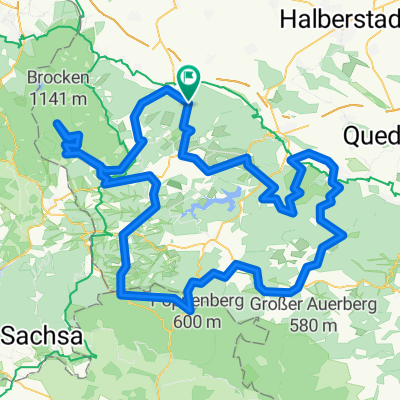
By train to Wernigerode, shortly after 9:00 a.m. we set off to the Bahnparallelweg, up to the Hotel Drei Annen then to the Glashüttenweg. Continued to Brockenbett and then along Brockenstraße to the summit. Brief stop (almost an hour). Down again the Brockenstraße and at about 900 m elevation at Brockenbett, turn left onto the Gelben Brink. At the first fork, continued to Stempelsbuche and then right towards Heinrich-Heine-Weg. Just before the curve straight onto Bremer Weg. At Bremer Hütte we kept left and descended the forest road, passing the Ilse falls, then turned left. After the bridge, there is a wonderful trail which, despite warnings, was very little used today. This path crosses another road and continues on the left side next to the Ilse river. From Ilsenburg just the R1 cycle route to Wernigerode. At the station, with Andreas, we went on to Halberstadt along the Holtemme cycle path to Halberstadt station. Waited 10 minutes and then continued by train.
- -:--
- Duration
- 76.1 km
- Distance
- 963 m
- Ascent
- 1,087 m
- Descent
- ---
- Avg. speed
- ---
- Max. altitude
Route highlights
Points of interest along the route
Point of interest after 0 km
zu Beginn erstmal ne Tasse Kaffee, warten auf Andreas. Er kommt mit Rad von Halberstadt
Point of interest after 12.5 km
Begegnung mit der Brockenbahn.
Point of interest after 13.5 km
1. Rast
Point of interest after 17.8 km
2. Rast
Point of interest after 27.2 km
Größere Pause (ca. 50 min)
Point of interest after 49.8 km
noch ein lecker Eis gegessen
Continue with Bikemap
Use, edit, or download this cycling route
You would like to ride Himmelfahrt 2012 or customize it for your own trip? Here is what you can do with this Bikemap route:
Free features
- Save this route as favorite or in collections
- Copy & plan your own version of this route
- Sync your route with Garmin or Wahoo
Premium features
Free trial for 3 days, or one-time payment. More about Bikemap Premium.
- Navigate this route on iOS & Android
- Export a GPX / KML file of this route
- Create your custom printout (try it for free)
- Download this route for offline navigation
Discover more Premium features.
Get Bikemap PremiumFrom our community
Other popular routes starting in Wernigerode
 Wernigerode: Brocken rauf und runter
- Distance
- 57.5 km
- Ascent
- 1,079 m
- Descent
- 1,078 m
- Location
- Wernigerode, Saxony-Anhalt, Germany
 Brockenrunde
- Distance
- 153 km
- Ascent
- 2,210 m
- Descent
- 2,116 m
- Location
- Wernigerode, Saxony-Anhalt, Germany
 Wernigerode -> Walkenried -> Thale Hbf.
- Distance
- 94.4 km
- Ascent
- 1,169 m
- Descent
- 1,017 m
- Location
- Wernigerode, Saxony-Anhalt, Germany
 Wernigerode - Brocken - Bad Harzburg - Wernigerode
- Distance
- 91.4 km
- Ascent
- 1,313 m
- Descent
- 1,313 m
- Location
- Wernigerode, Saxony-Anhalt, Germany
 Große Dammstraße 32, Wernigerode nach Große Dammstraße 32, Wernigerode
- Distance
- 16.5 km
- Ascent
- 16 m
- Descent
- 7 m
- Location
- Wernigerode, Saxony-Anhalt, Germany
 Eine kleine Abendrunde bei Wernigerode
- Distance
- 24.2 km
- Ascent
- 125 m
- Descent
- 125 m
- Location
- Wernigerode, Saxony-Anhalt, Germany
 Brockentour
- Distance
- 39.9 km
- Ascent
- 1,133 m
- Descent
- 977 m
- Location
- Wernigerode, Saxony-Anhalt, Germany
 Wernigerode HarzW-134km (RK) Königsetappe
- Distance
- 133.8 km
- Ascent
- 1,425 m
- Descent
- 1,425 m
- Location
- Wernigerode, Saxony-Anhalt, Germany
Open it in the app