

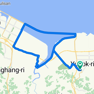
대덕동 376-1번지, 당진시 ~ 대덕마을5단지아파트앞, 당진시
A cycling route starting in Tangjin, Chungcheongnam-do, South Korea.
Overview
About this route
- 5 h 47 min
- Duration
- 64.2 km
- Distance
- 1,268 m
- Ascent
- 1,268 m
- Descent
- 11.1 km/h
- Avg. speed
- 264 m
- Max. altitude
Route quality
Waytypes & surfaces along the route
Waytypes
Quiet road
37.2 km
(58 %)
Road
8.3 km
(13 %)
Surfaces
Paved
0.6 km
(1 %)
Unpaved
8.3 km
(13 %)
Ground
8.3 km
(13 %)
Paved (undefined)
0.6 km
(1 %)
Undefined
55.2 km
(86 %)
Continue with Bikemap
Use, edit, or download this cycling route
You would like to ride 대덕동 376-1번지, 당진시 ~ 대덕마을5단지아파트앞, 당진시 or customize it for your own trip? Here is what you can do with this Bikemap route:
Free features
- Save this route as favorite or in collections
- Copy & plan your own version of this route
- Sync your route with Garmin or Wahoo
Premium features
Free trial for 3 days, or one-time payment. More about Bikemap Premium.
- Navigate this route on iOS & Android
- Export a GPX / KML file of this route
- Create your custom printout (try it for free)
- Download this route for offline navigation
Discover more Premium features.
Get Bikemap PremiumFrom our community
Other popular routes starting in Tangjin
 송산면 410-49 ~ 송산면 410-49
- Distance
- 32.3 km
- Ascent
- 204 m
- Descent
- 260 m
- Location
- Tangjin, Chungcheongnam-do, South Korea
 신평면 806-1 ~ 신평면 807-2
- Distance
- 7.2 km
- Ascent
- 10 m
- Descent
- 36 m
- Location
- Tangjin, Chungcheongnam-do, South Korea
 읍내동 1642, 당진시 ~ 읍내동 1540, 당진시
- Distance
- 53.4 km
- Ascent
- 223 m
- Descent
- 228 m
- Location
- Tangjin, Chungcheongnam-do, South Korea
 개심사 예정
- Distance
- 60.8 km
- Ascent
- 1,564 m
- Descent
- 1,575 m
- Location
- Tangjin, Chungcheongnam-do, South Korea
![수청동Ph0]으로 라우팅](https://media.bikemap.net/routes/17589073/staticmaps/in_b32044b0-93c1-4c31-af1c-8e8f5758fc8b_400x400_bikemap-2021-3D-static.png) 수청동Ph0]으로 라우팅
수청동Ph0]으로 라우팅- Distance
- 14.4 km
- Ascent
- 132 m
- Descent
- 145 m
- Location
- Tangjin, Chungcheongnam-do, South Korea
![Ph0]에서 경로순성면 893-7](https://media.bikemap.net/routes/17582524/staticmaps/in_e421e644-91b6-4f4e-8d6c-a21137ed93f9_400x400_bikemap-2021-3D-static.png) Ph0]에서 경로순성면 893-7
Ph0]에서 경로순성면 893-7- Distance
- 11.3 km
- Ascent
- 123 m
- Descent
- 149 m
- Location
- Tangjin, Chungcheongnam-do, South Korea
 보통 경로
보통 경로- Distance
- 12.8 km
- Ascent
- 90 m
- Descent
- 118 m
- Location
- Tangjin, Chungcheongnam-do, South Korea
![송악읍 481, 당진시Ph0]으로 라우팅](https://media.bikemap.net/routes/13731894/staticmaps/in_0a69b7ad-1cd1-446a-b616-0c7c13ad694c_400x400_bikemap-2021-3D-static.png) 송악읍 481, 당진시Ph0]으로 라우팅
송악읍 481, 당진시Ph0]으로 라우팅- Distance
- 20.1 km
- Ascent
- 107 m
- Descent
- 80 m
- Location
- Tangjin, Chungcheongnam-do, South Korea
Open it in the app