
Niers-Radtour von Quelle
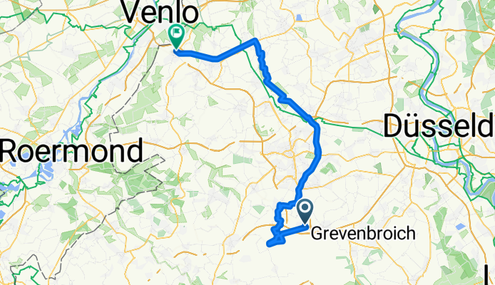
A cycling route starting in Jüchen, North Rhine-Westphalia, Germany.
Overview
About this route
Die Quellen der Niers Die Niers ist ca. 114 km lang. Sie entspringt in Erkelenz-Kuckum und mündet bei Gennep (NL) in die Maas. Die Niers hatte früher im Gebiet von Erkelenz Kuckum insgesamt drei wesentliche Quellen. Infolge des Braunkohleabbaus Garzweiler I sind diese inzwischen mehr oder minder vollständig versiegt: Um die Braunkohle im Tagebau gewinnen zu können, wurde nämlich der Grundwasserstand durch Pumpmaßnahmen sehr stark abgesenkt. Jedoch wurde der Betreiber der Tagebau, das Unternehmen Rheinbraun, verpflichtet, das abgepumpte Grundwasser zu Teilen in den Lauf der Niers einzuleiten. Heute wird ca. 80-90% des Wassers der Niers künstlich zugeleitet.
- -:--
- Duration
- 62.7 km
- Distance
- 57 m
- Ascent
- 105 m
- Descent
- ---
- Avg. speed
- ---
- Max. altitude

Route quality
Waytypes & surfaces along the route
Waytypes
Path
33 km
(53 %)
Track
13.6 km
(22 %)
Surfaces
Paved
36.9 km
(59 %)
Unpaved
21 km
(34 %)
Asphalt
32.4 km
(52 %)
Gravel
12.2 km
(19 %)
Route highlights
Points of interest along the route

Photo after 7.9 km
Die junge Niers

Photo after 19 km
Niers bei Mönchengladbach-Odenkirchen

Photo after 22.5 km
Rheydt Park Niers

Photo after 31.3 km
Niers

Accommodation after 38 km
China Restaurant Shang Hai-Garten Krefelder Str. 282, 41748 Viersen Mo - Sa: 11:00 - 15:00 Uhr, Tel. 02162 10 32 38

Photo after 41.9 km
An der Niers ist das Radeln immer wieder schön.

Photo after 51.6 km
Bahntrassenradweg

Photo after 58 km
Bahntrassenradweg
Continue with Bikemap
Use, edit, or download this cycling route
You would like to ride Niers-Radtour von Quelle or customize it for your own trip? Here is what you can do with this Bikemap route:
Free features
- Save this route as favorite or in collections
- Copy & plan your own version of this route
- Sync your route with Garmin or Wahoo
Premium features
Free trial for 3 days, or one-time payment. More about Bikemap Premium.
- Navigate this route on iOS & Android
- Export a GPX / KML file of this route
- Create your custom printout (try it for free)
- Download this route for offline navigation
Discover more Premium features.
Get Bikemap PremiumFrom our community
Other popular routes starting in Jüchen
 Radeln für die Seele. Tagebau Garweiler
- Distance
- 49.4 km
- Ascent
- 222 m
- Descent
- 223 m
- Location
- Jüchen, North Rhine-Westphalia, Germany
 Eiscafé Europa
- Distance
- 11 km
- Ascent
- 35 m
- Descent
- 48 m
- Location
- Jüchen, North Rhine-Westphalia, Germany
 schloss Jüchen
- Distance
- 20.4 km
- Ascent
- 40 m
- Descent
- 40 m
- Location
- Jüchen, North Rhine-Westphalia, Germany
 WeyO-Dyck-Schlich
- Distance
- 7.4 km
- Ascent
- 10 m
- Descent
- 23 m
- Location
- Jüchen, North Rhine-Westphalia, Germany
 Braunkohle Otzenrath
- Distance
- 20.9 km
- Ascent
- 63 m
- Descent
- 66 m
- Location
- Jüchen, North Rhine-Westphalia, Germany
 Zur Allrather Höhe
- Distance
- 58.2 km
- Ascent
- 150 m
- Descent
- 142 m
- Location
- Jüchen, North Rhine-Westphalia, Germany
 Mönchengladbacher Wald- und Parktour
- Distance
- 38.6 km
- Ascent
- 121 m
- Descent
- 121 m
- Location
- Jüchen, North Rhine-Westphalia, Germany
 30km Route
- Distance
- 29.3 km
- Ascent
- 67 m
- Descent
- 66 m
- Location
- Jüchen, North Rhine-Westphalia, Germany
Open it in the app