
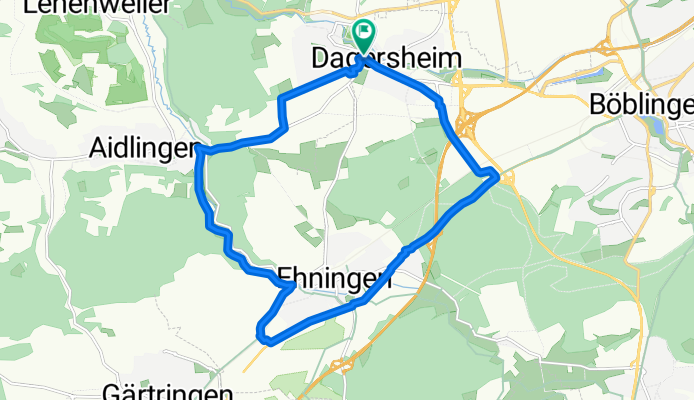
Dagersheim - Ehningen - Aidlingen
A cycling route starting in Ehningen, Baden-Wurttemberg, Germany.
Overview
About this route
Für Rennradfahrer - Zwischen Ehningen und Aidlingen im Tal führt eine schöne Straße lang die sich, wie der Radweg abseits der Straße, durch das Tal schlängelt.
- -:--
- Duration
- 16.1 km
- Distance
- 171 m
- Ascent
- 165 m
- Descent
- ---
- Avg. speed
- 482 m
- Max. altitude

Route quality
Waytypes & surfaces along the route
Waytypes
Track
6.9 km
(43 %)
Path
3.4 km
(21 %)
Surfaces
Paved
14.2 km
(88 %)
Unpaved
1.5 km
(9 %)
Asphalt
14 km
(87 %)
Loose gravel
1.5 km
(9 %)
Continue with Bikemap
Use, edit, or download this cycling route
You would like to ride Dagersheim - Ehningen - Aidlingen or customize it for your own trip? Here is what you can do with this Bikemap route:
Free features
- Save this route as favorite or in collections
- Copy & plan your own version of this route
- Sync your route with Garmin or Wahoo
Premium features
Free trial for 3 days, or one-time payment. More about Bikemap Premium.
- Navigate this route on iOS & Android
- Export a GPX / KML file of this route
- Create your custom printout (try it for free)
- Download this route for offline navigation
Discover more Premium features.
Get Bikemap PremiumFrom our community
Other popular routes starting in Ehningen
 Königliche Jagdhütte
- Distance
- 41.2 km
- Ascent
- 525 m
- Descent
- 520 m
- Location
- Ehningen, Baden-Wurttemberg, Germany
 Würmtal-Nagoldtal Runde
- Distance
- 103.9 km
- Ascent
- 468 m
- Descent
- 468 m
- Location
- Ehningen, Baden-Wurttemberg, Germany
 Ehningen-Bondorf
- Distance
- 57.1 km
- Ascent
- 351 m
- Descent
- 351 m
- Location
- Ehningen, Baden-Wurttemberg, Germany
 Moderate route in Ehningen
- Distance
- 13.3 km
- Ascent
- 81 m
- Descent
- 80 m
- Location
- Ehningen, Baden-Wurttemberg, Germany
 Ehningen Abendrunde
- Distance
- 25.5 km
- Ascent
- 207 m
- Descent
- 183 m
- Location
- Ehningen, Baden-Wurttemberg, Germany
 Kleine Schönbuch-Tour von Ehningen
- Distance
- 33.8 km
- Ascent
- 286 m
- Descent
- 347 m
- Location
- Ehningen, Baden-Wurttemberg, Germany
 heimspiel Schönbuch
- Distance
- 35.7 km
- Ascent
- 235 m
- Descent
- 235 m
- Location
- Ehningen, Baden-Wurttemberg, Germany
 Kleine Schönbuchrunde Goldersbachtal
- Distance
- 35.7 km
- Ascent
- 317 m
- Descent
- 317 m
- Location
- Ehningen, Baden-Wurttemberg, Germany
Open it in the app