

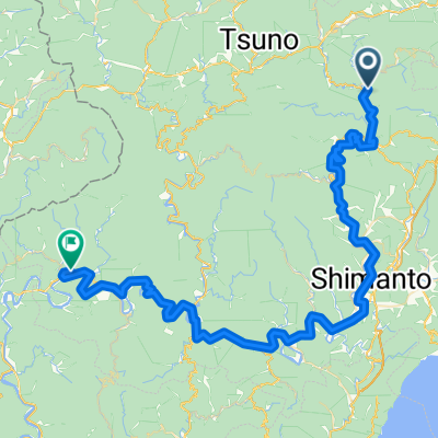
Day 561
A cycling route starting in Susaki, Kochi, Japan.
Overview
About this route
- -:--
- Duration
- 52.2 km
- Distance
- 428 m
- Ascent
- 429 m
- Descent
- ---
- Avg. speed
- 134 m
- Max. altitude

Continue with Bikemap
Use, edit, or download this cycling route
You would like to ride Day 561 or customize it for your own trip? Here is what you can do with this Bikemap route:
Free features
- Save this route as favorite or in collections
- Copy & plan your own version of this route
- Sync your route with Garmin or Wahoo
Premium features
Free trial for 3 days, or one-time payment. More about Bikemap Premium.
- Navigate this route on iOS & Android
- Export a GPX / KML file of this route
- Create your custom printout (try it for free)
- Download this route for offline navigation
Discover more Premium features.
Get Bikemap PremiumFrom our community
Other popular routes starting in Susaki
 Day 561
- Distance
- 52.2 km
- Ascent
- 428 m
- Descent
- 429 m
- Location
- Susaki, Kochi, Japan
 Steady ride in Susaki-Shiñnvmmnmc
- Distance
- 0.1 km
- Ascent
- 5 m
- Descent
- 12 m
- Location
- Susaki, Kochi, Japan
 Moderate route in Nakatosa-Cho, Takaoka-Gun
- Distance
- 0.3 km
- Ascent
- 12 m
- Descent
- 4 m
- Location
- Susaki, Kochi, Japan
 Easy ride in Susaki-Shivncnbccbbncbcnbncnv
- Distance
- 0.1 km
- Ascent
- 0 m
- Descent
- 23 m
- Location
- Susaki, Kochi, Japan
 shikoka trip day10
- Distance
- 50 km
- Ascent
- 614 m
- Descent
- 469 m
- Location
- Susaki, Kochi, Japan
 shikoku final 01.11.2019
- Distance
- 82.8 km
- Ascent
- 269 m
- Descent
- 524 m
- Location
- Susaki, Kochi, Japan
 ;jdsfkasj
- Distance
- 109.5 km
- Ascent
- 1,092 m
- Descent
- 1,094 m
- Location
- Susaki, Kochi, Japan
 Restful route in Susaki-Shi
- Distance
- 0.2 km
- Ascent
- 23 m
- Descent
- 24 m
- Location
- Susaki, Kochi, Japan
Open it in the app